Ytrebygda
| Ytrebygda bydel | ||
|---|---|---|
| Borough | ||
| ||
| Coordinates: 60°17′31″N 005°16′37″E / 60.29194°N 5.27694°ECoordinates: 60°17′31″N 005°16′37″E / 60.29194°N 5.27694°E | ||
| Country | Norway | |
| City | Bergen | |
| Area | ||
| • Total | 39.61 km2 (15.29 sq mi) | |
| Area rank | 4th | |
| ca. 8% of total | ||
| Population (2008) | ||
| • Total | 24,044 | |
| • Rank | 7th | |
| • Density | 610/km2 (1,600/sq mi) | |
| 9.70% of total | ||
| Time zone | CET (UTC+1) | |
| • Summer (DST) | CEST (UTC+2) | |
| ISO 3166 code | NO-120106 | |

Ytrebygda is a borough of the city of Bergen, Norway.
Location
Ytrebygda is located southwest of the city center. It was originally part of Fana municipality that was incorporated in Bergen in 1972, and later part of the Fana district, but was administratively a separate district in 1990. Ytrebygda borders Fana district in the east and the Fana Fjord in the south.
Apart from the residential neighborhoods, Ytrebygda has a large office area in the Kokstad and Sandsli area, with large office buildings for companies such as StatoilHydro and Norsk Hydro. The city's airport, Bergen Airport, Flesland, is located in the western part of the borough. Just north of Airport Road is Siljustøl Museum. South of Airport Road is the Bergen Yacht Club (Bergens Seilforening), Golf Club and Fana Stadium. On the far south is Milde Arboretum and Botanical Garden, Fana College (Fana Folkehøgskule), and Store Milde.
Local Attractions
- Milde Arboretum and Botanical Garden – 125 acre garden which are planted with a large variety of trees and shrubs[1]
- Siljustøl Museum – Former home of composer Harald Sæverud, managed by the Bergen Art Museum.[2]
- Store Milde – Manor house in the Rococo style of the Renaissance garden
Picture gallery
-
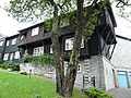
Siljustøl Museum
-
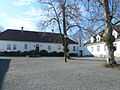
Store Milde Manor
-

Fana Statium
-
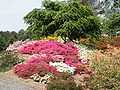
Milde Arboretum and Botanical Garden
-

Blondehuset at Milde Arboretum
References
Other sources
- Hjellestad and Milde and Historical Society (1998) Herregarden Milde. Eigarane gjennom 290 år. 1530–1820; i Liv og lagnad i Neset
External links
| Wikimedia Commons has media related to Ytrebygda. |
| |||||||