Yenisei Gulf

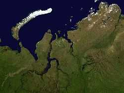
The Yenisei Gulf (Russian: Енисейский залив) is a large and long estuary through which the lower Yenisei River flows into the Kara Sea. The Yenisei Gulf is formed by the river widening to an average of 50 km for up to 250 km in a roughly north-south direction, between a latitude of 70° 30' N in the area around Munguy settlement, north of Dudinka. The whole region of the lower Yenisei is bleak and sparsely inhabited, and the settlements are built on permafrost ground. There is no vegetation except for mosses, lichens and some grass.
The maximum depth of Yenisei Gulf is 208 feet (63 m).
The mouth of the Yenisei Gulf is roughly located at 72° 30’ N, in the area of Sibiryakov Island, in the Kara Sea.
Islands
- The Yenisei has some flat, low-lying islands at its southern end, the Brekhovsky Islands (Бреховские острова) 70°30′N 82°45′E / 70.500°N 82.750°E. They stand where the river flows into the estuary. Lakes and swamps surround this area, which features many arms through which lesser rivers of the tundra flow across wetlands into the Yenisei basin.
- Further northwards the Yenisei widens and becomes a clear expanse. The water turns brackish at this point. There are three small islands located almost in the middle of the gulf, the Bolshoi Korsakovsky Islands (острова Большой Корсаковский ). The largest one is 4 km long and 1.2 km wide. 72°17′N 81°01′E / 72.283°N 81.017°E. Burnyy Island is located right in the middle of the gulf. Chaishnyy is the closest to the shore.
- Krestovskiy or Krestovsky Island (Остров Крестовский) lies a further 9 km to the NNW, close to the eastern shore of the Yenisei Gulf. It is 7.5 km long and 1.8 km wide.72°24′N 80°47′E / 72.400°N 80.783°E. This island takes its name from the Russian writer Vsevolod Vladimirovich Krestovskiy (1840-1895).
Climate
The weather pattern in this desolate area is severe, with long and bitter winters and frequent blizzards and gales. The Yenisei estuary is frozen for about nine months in a year and even in summer it is never quite free of ice floes. During the winter the shipping lanes are kept open by icebreaker.
Administration
The Yenisei Gulf and all its islands belong to the Krasnoyarsk Krai administrative division of the Russian Federation and is part of the Great Arctic State Nature Reserve, the largest nature reserve of Russia.
References
- Islands in the Yenisei Gulf (Russian)
- Colin Thubron, In Siberia.
- Dissolved organic matter (DOM) in the estuary of the Yenisei
- Salt intrusions in Siberian river estuaries
- Freight map
- Pictures
- German-Russian project on Siberian River Run-off
Coordinates: 72°30′N 81°15′E / 72.500°N 81.250°E