Yeghegnadzor
| Yeghegnadzor Եղեգնաձոր | |
|---|---|
 | |
 Yeghegnadzor Եղեգնաձոր | |
| Coordinates: 39°45′40″N 45°20′00″E / 39.76111°N 45.33333°ECoordinates: 39°45′40″N 45°20′00″E / 39.76111°N 45.33333°E | |
| Country |
|
| Marz | Vayots Dzor |
| First mentioned | 5th century |
| Government | |
| • Mayor | David Harutyunuan |
| Area | |
| • Total | 6 km2 (2 sq mi) |
| Elevation | 1,194 m (3,917 ft) |
| Population (2009) | |
| • Total | 8,200 |
| • Density | 1,400/km2 (3,500/sq mi) |
| Time zone | GMT +4 (UTC+4) |
| Area code(s) | (+374) 281 |
| Website | official website |
| Sources: Population [1] | |
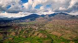
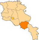
Yeghegnadzor (Armenian: Եղեգնաձոր); anciently Yeghegik, until 1935 Keshishkend, between 1935 and 1957 Mikoyan, is the capital of the Armenian province of Vayots Dzor. The name of the city means "the valley of canes" in the Armenian language. During the rule of Joseph Stalin, the city was renamed after the Soviet politician Anastas Mikoyan. The town is located 123 km south of the capital Yerevan, on a small river called "Serkoghunk" (Armenian: Սրկողունք), at a height of 1194 meters above sea level.[2]
General information
Yeghegnadzor is one of the ancient settlements of the Vayots Dzor canton within the historic province of Syunik; the 9th province of Greater Armenia (Armenia Major). It was first mentioned in history during the 5th century. The ruins of a medieval fortress could be found near the city.
The economy of the town is based on the construction sector and food-processing industry. The most notable industrial plant of the toen is the wine factory. There are many firms as well for electro-mechanical tools production. Lighter productions of canned foods, textile and jewellery are also found in the town.
However, the agricultural sector remains the main activity of the population in the suburbs of Yeghegnadzor.
Education and sports
The town has four public education schools, three kindergartens, one intermediate college, one music and art school and one sport school. The geological museum of the town was opened in 2002. Yeghegnadzor is home to Arpa FC football club which is currently inactive.
Historic sites
- Basilica of the Holy Mother of God: formerly known as Surp Sarkis church, built in the 12th century and renovated in 1878. The basilica is located at the centre of Yeghegnadzor and serves as the seat of the Vayots Dzor Diocese of the Armenian Apostolic Church.[3]
- Proshaberd fortress (Boloraberd fortress) of the 13th century, located few kilometers to the north-east of Yeghegnadzor, near the villages of Gladzor and Vernashen.
- The historic "University of Gladzor" of the 13th century, located in the village of Gladzor at the outskirts of Yeghegnadzor.
- Noravank Monastery of the 13th century, located few kilometers away from Yeghegnadzor, to the southwest of the town.
- Spitakavor Monastery of the Holy Mother of God built in 1321, located just to the north of Yeghegnadzor near the village of Vernashen.

References
- ↑ Armstats:Population
- ↑ Yeghegnadzor:Armenia page Archived 22 January 2011 at WebCite
- ↑ Historical sites in Vayots Dzor
- '32FA881E67E43774E0440003BA962ED3'&Diacritics=DC Yeghegnadzor at GEOnet Names Server
- Report of the results of the 2001 Armenian Census, National Statistical Service of the Republic of Armenia
- World Gazeteer: Armenia – World-Gazetteer.com
- Kiesling, Brady (2005), Rediscovering Armenia: Guide, Yerevan, Armenia: Matit Graphic Design Studio
- Brady Kiesling, Rediscovering Armenia, p. 125; original archived at Archive.org, and current version online on Armeniapedia.org.
External links
| |||||||||||||||||
