Yaiza (municipality)
| Yaiza | ||
|---|---|---|
| Municipality | ||
| ||
 | ||
| Coordinates: 28°57′7″N 13°45′51″W / 28.95194°N 13.76417°W | ||
| Country |
| |
| Autonomous Community |
| |
| Province | Las Palmas | |
| Island | Lanzarote | |
| Government | ||
| • Mayor | Gladis Acuña Machín (PIL) | |
| Area | ||
| • Total | 212 km2 (82 sq mi) | |
| Elevation(AMSL) | 192 m (630 ft) | |
| Population (2012) | ||
| • Total | 15,131 | |
| • Density | 71/km2 (180/sq mi) | |
| Time zone | CET (UTC+0) | |
| • Summer (DST) | CEST (GMT +1) (UTC+1) | |
| Postal code | 35570 | |
| Area code(s) | +34 (Spain) + 928 (Las Palmas) | |
| Website | www.yaiza.org | |
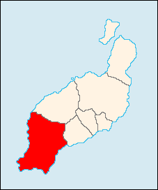
Yaiza is a municipality on the island of Lanzarote in the Canary Islands, Spain. It lies in the southwest of the island and forms part of the province of Las Palmas.
The municipality is bounded by the Atlantic Ocean to the west, south and east. In the west is the lagoon of Charco Verde, which has a green pond and a colourful rim. To the north part of the Timanfaya National Park is within the municipality. The eastern part of the municipality is mountainous, and south west of the mountains the Rubicon plain stretches to the coast.
The largest town of the municipality is Playa Blanca on the south coast. The administrative centre is the much smaller town of Yaiza.
The population is 9,664[1] and the area is 211.84 sq km. The main industries are agriculture and tourism.
Highway LZ2 connects Playa Blanca and the town of Yaiza to Arrecife to the east.
Yaiza is the only municipality on Lanzarote to contain two marinas: Rubicon Marina at Playa Blanca, and Puerto Calero on the east coast.
Sites of interest
- El Golfo
- Playa Blanca (meaning white beach), a beach located in the extreme south of Yaiza.
- Hacha Grande, a mountain
- Puerto Calero marina
Gallery
-

Playa de Papagayo
-

Hacha Grande, a mountain in the south of Yaiza, viewed from the road to the Playa de Papagayo
See also
References
External links
- Official website (in Spanish)
| North: Tinajo | Northeast: Tías | |
| West: Atlantic Ocean |
Yaiza | East: Tías and the Atlantic Ocean |
| South: Atlantic Ocean |
Coordinates: 28°57′0″N 13°45′0″W / 28.95000°N 13.75000°W
| |||||||
