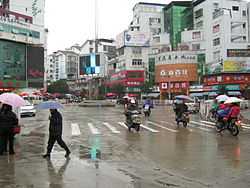
Wuyishan, Fujian
| Wuyishan 武夷山 | |
|---|---|
| County-level city | |
| 武夷山市 | |
 | |
 | |
 Wuyishan | |
| Coordinates: 27°46′N 118°02′E / 27.767°N 118.033°ECoordinates: 27°46′N 118°02′E / 27.767°N 118.033°E | |
| Country | People's Republic of China |
| Province | Fujian |
| Prefecture-level city | Nanping |
| Time zone | China Standard (UTC+8) |
Wuyishan City (Chinese: 武夷山市; pinyin: Wǔyíshān shì) is a county-level city in the municipal region of Nanping, in the northwest of Fujian province, People's Republic of China. It corresponds to the former Chong'an County.[1]
Natural and Cultural Heritage
A local subsection of the Wuyishan Mountain range, which forms the entirety of the geological and political divide between the provinces of Fujian and Jiangxi, is a front-rank national park called simply Wuyi (武夷) Mountains. Since 1999 the park zone has been recognised by UNESCO as part of the world's natural and cultural heritage.
Cultural sites within the zone include the original cultivation ground of the Dahongpao (大红袍) tea variety, and a villa retreat used by Zhu Xi, a Confucian revivalist scholar-official of the rump or Southern Song Empire.
South of the zone, just short of the City's border with Jianyang City, is a major archaeological excavation of the vanished Yue (越) nation.
Administration
The city executive, legislature and judiciary are in CongAn Street Office (崇安街道), together with the CPC and PSB branches.
There are two other Street offices :
- Xinfeng (新丰街道) - formerly Chengdong Township (城东乡)
- Wuyi (武夷街道) - formerly Wuyi Town (武夷镇)
Towns (镇, zhen)
- Xingcun (星村镇) - embarkation for raft-tours down the Jiuquxi River (九曲溪)
- Xingtian (兴田镇)
- Wufu (五夫镇)
Townships (乡, xiang)
- Shangmei (上梅乡)
- Wutun (吴屯乡)
- Ganggu (岚谷乡)
- Yangzhuang (洋庄乡)
Transportation
The Nanping Wuyishan Airport serves the Wuyishan area. The Hengfeng–Nanping Railway passes through Wuyishan.
References
- ↑ "Nanping Travel Guide". TravelChinaGuide. 1998-2013. Retrieved 1 September 2013.
| |||||||||||||||||||||||||||||||||||||||