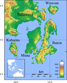
Wowoni Island
From Wikipedia, the free encyclopedia
 | |
| Geography | |
|---|---|
| Location | South East Asia |
| Coordinates | 4°08′S 123°06′E / 4.133°S 123.100°E |
| Area | 715 km2 (276 sq mi) |
| Country | |
|
Indonesia | |
| Demographics | |
| Population | 28,944 (as of 2010 Census) |
| Density | 40.48 /km2 (104.84 /sq mi) |
Wawonii (formerly called Wowoni) is an island in the Banda Sea, Indonesia, off the south east coast of Sulawesi. Its area is 715 km². From 2013, it forms a regency of its own within Southeast Sulawesi Province, having previously been a part of Konawe Regency; the new Regency, which comprises the seven districts on Wawonii Island, is named Konawe Kepulauan Regency (Konawe Islands Regency). The administrative capital of the new Regency is Langara (in West Wawonii District).
Administration
Konawe Kepulauan Regency, which is coincident with Wawonii Island, is divided into seven districts (kecamatan), tabulated below with their 2010 Census population.
| Name | English name | Population Census 2010[1] |
|---|---|---|
| Wawonii Selatan | (South Wawonii) | 3,276 |
| Wawonii Barat | (West Wawonii) | 6,410 |
| Wawonii Tengah | (Central Wawonii) | 2,990 |
| Wawonii Tenggara | (Southeast Wawonii) | 5,304 |
| Wawonii Timur | (East Wawonii) | 2,814 |
| Wawonii Utara | (North Wawonii) | 5,067 |
| Wawonii Timur Laut | (Northeast Wawonii) | 3,083 |
References
- ↑ Biro Pusat Statistik, Jakarta, 2011
This article is issued from Wikipedia. The text is available under the Creative Commons Attribution/Share Alike; additional terms may apply for the media files.