Winterton-on-Sea
| Winterton-on-Sea | |
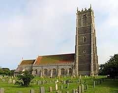
 The Church of the Holy Trinity & All Saints |
|
 Winterton-on-Sea | |
| Area | 5.70 km2 (2.20 sq mi) |
|---|---|
| Population | 1,359 |
| - Density | 238 /km2 (620 /sq mi) |
| OS grid reference | TG488193 |
| Civil parish | Winterton |
| District | Great Yarmouth (borough) |
| Shire county | Norfolk |
| Region | East |
| Country | England |
| Sovereign state | United Kingdom |
| Post town | GREAT YARMOUTH |
| Postcode district | NR29 |
| Dialling code | 01493 |
| Police | Norfolk |
| Fire | Norfolk |
| Ambulance | East of England |
| EU Parliament | East of England |
| UK Parliament | Great Yarmouth |
Winterton-on-Sea is a village and civil parish in the English county of Norfolk. As its name suggests, it is situated on the coast some 13 km (8.1 mi) north of the town of Great Yarmouth and 30 km (19 mi) east of the city of Norwich.[1]
Introduction
The civil parish has an area of 5.7 km2 (2.2 sq mi) and in the 2001 census had a population of 1,359 in 589 households. Winterton-on-Sea borders the villages of Hemsby, Horsey and Somerton. For the purposes of local government, the parish falls within the district of Great Yarmouth.[2]
Between the village of Winterton-on-Sea and the North Sea are the Winterton Dunes which are inhabited by several notable species such as the Natterjack Toad.Winterton-on-Sea has received awards on several occasions in the Anglia in Bloom competition.[3]
The Holy Trinity and All Saints church situated in Winterton-on-Sea dates back to the 16th Century and is 38m tall.[4]
Winterton men & lifeboats
Between 1851 and 1861 a number of Winterton families migrated South to Caister. Many of those families joined the Caister Beachmen and founded arguably the basis of the modern Lifeboat service. The most notable of these men was James Haylett.
Winterton as a resort
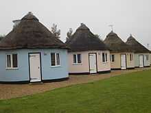
Overlooking the coastline at Winterton-on-Sea is the Hermanus holiday camp; a popular holiday destination, complete with restaurant, bar and thatched accommodation referred to locally as 'roundhouses'.[5] The roundhouses were inspired by a previous owner's trip to Hermanus Bay in South Africa.[6]
The hazardous nature of the coastline at Winterton-on-Sea is marked by its lighthouse whose history extends from James I to the First World War[7]
In the late eighteenth century marram grass was planted to stabilise the coastline against sea encroachments and by the early nineteenth century there was a barrier of dunes between high water mark and the ridge on which the lighthouse stood, leaving a valley (The Valley) between.[8]
During World War II, anti-invasion defences were constructed around Winterton-on-Sea. They included a number of pillboxes. The beaches were protected with unusually extensive barriers of scaffolding and large numbers of anti-tank cubes.[9]
See also
References
Notes
- Winterton-0n-Sea/history notes - a sub-page to collect history notes before formalising them, and adding a section to this page.
- ↑ Ordnance Survey (2002). OS Explorer Map 252 - Norfolk Coast East. ISBN 0-319-21888-0.
- ↑ "Census population and household counts for unparished urban areas and all parishes". Office for National Statistics & Norfolk County Council (2001). p. 1. Retrieved December 2, 2005. Retrieved December 2, 2005..
- ↑
- ↑
- ↑ "Hermanus Leisure".
- ↑ "Property And Accommodation". Hermanus Leisure. p. 1. Retrieved 2009-09-08.
- ↑ .
- ↑ Long, Neville (1983). Lights of East Anglia.
- ↑ Foot, William (2006). Beaches, fields, streets, and hills ... the anti-invasion landscapes of England, 1940. Council for British Archaeology. ISBN 1-902771-53-2.
External links
| Wikimedia Commons has media related to Winterton-on-Sea. |
- Information from Genuki Norfolk on Winterton-on-Sea.
- Winterton-on-Sea village website
- http://www.winterton-on-sea.net/winterton_in_bloom/index.htm
- http://www.winterton-on-sea.net/churches/holytrinitychurch.htm
- http://www.norfolkcoast.co.uk/location_norfolk/vp_wintertononsea.htm
- Winterton-On-Sea.com - Places of interest, where to stay etc
| ||||||||
