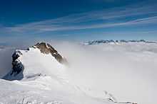
Wildhorn
| Wildhorn | |
|---|---|
 View from the north side | |
| Elevation | 3,248 m (10,656 ft) |
| Prominence | 978 m (3,209 ft)[1] |
| Parent peak | Finsteraarhorn |
| Location | |
 Wildhorn | |
| Location | Bern/Valais, Switzerland |
| Range | Bernese Alps |
| Coordinates | 46°21′16.5″N 7°21′39.1″E / 46.354583°N 7.360861°ECoordinates: 46°21′16.5″N 7°21′39.1″E / 46.354583°N 7.360861°E |
| Climbing | |
| First ascent | September 1843 by Gottlieb Samuel Studer |
The Wildhorn (3,248 m) is the highest peak of the Wildhorn group in the Bernese Alps. The first ascent was made by Gottlieb Samuel Studer in September 1843.

The mountain forms the boundary between the Canton of Valais and the Canton of Berne. Two small glaciers lie on the east face of the Wildhorn: the Glacier des Audannes and the Glacier de Ténéhet. The Tungelgletscher, a glacier measured as 1.9 km in length in 1973,[2] has its source on the mountain's north-east face.
The Swiss Alpine Club maintains the Wildhornhütte shelter (2,303 m) in the Iffigtal, above the Iffigsee, on the northern slopes of the mountain. The easiest ascent (a glacier tour) starts from there. More challenging ascents commence from the Geltenhütte (2,759 m), above the Col du Brochet.
- This article incorporates information from the revision as of 10 January 2008 of the equivalent article on the German Wikipedia.
External links
- The Wildhorn on SummitPost
- Wildhorn (German)
- Geltenhütte website (German)
- Wildhornhütte website (German)
- Tour du Wildhorn website
References
- ↑ Retrieved from the Swisstopo topographic maps. The key col is the Gemmi Pass (2,270 m).
- ↑ http://glaciology.ethz.ch/messnetz/glaciers/dungel.html Date accessed: 10 January 2008