Wildenbörten
From Wikipedia, the free encyclopedia
| Wildenbörten | |
|---|---|
 Wildenbörten | |
Location of Wildenbörten within Altenburger Land district 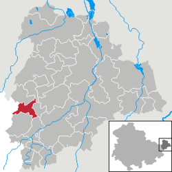 | |
| Coordinates: 50°54′45″N 12°17′11″E / 50.91250°N 12.28639°ECoordinates: 50°54′45″N 12°17′11″E / 50.91250°N 12.28639°E | |
| Country | Germany |
| State | Thuringia |
| District | Altenburger Land |
| Municipal assoc. | Oberes Sprottental |
| Subdivisions | 5 |
| Government | |
| • Mayor | Gerhard Fischer |
| Area | |
| • Total | 7.81 km2 (3.02 sq mi) |
| Elevation | 240-295 m (−728 ft) |
| Population (2012-12-31)[1] | |
| • Total | 306 |
| • Density | 39/km2 (100/sq mi) |
| Time zone | CET/CEST (UTC+1/+2) |
| Postal codes | 04626 |
| Dialling codes | 034491 |
| Vehicle registration | ABG |
| Website | www.wildenboerten.de |
Wildenbörten a German municipality in the Thuringian district of Altenburger Land. It belongs to the Verwaltungsgemeinschaft of Oberes Sprottental.
Geography
Neighboring municipalities
Municipalities near Wildenbörten are Drogen, Löbichau, Lumpzig, Mehna, and Nöbdenitz in the district of Altenburger Land; as well as Großenstein und Reichstädt in district of Greiz.
Municipal organization
The municipality of Wildenbörten consists of five subdivisions: Wildenbörten, Dobra, Graicha, Hartroda, and Kakau.
References
- ↑ "Bevölkerung der Gemeinden, erfüllenden Gemeinden und Verwaltungsgemeinschaften nach Geschlecht in Thüringen". Thüringer Landesamt für Statistik (in German). 13 July 2013.
This article is issued from Wikipedia. The text is available under the Creative Commons Attribution/Share Alike; additional terms may apply for the media files.