Wieda
From Wikipedia, the free encyclopedia
| Wieda | ||
|---|---|---|
| ||
 Wieda | ||
Location of Wieda within Osterode am Harz district 
 | ||
| Coordinates: 51°37′57″N 10°35′09″E / 51.63250°N 10.58583°ECoordinates: 51°37′57″N 10°35′09″E / 51.63250°N 10.58583°E | ||
| Country | Germany | |
| State | Lower Saxony | |
| District | Osterode am Harz | |
| Municipal assoc. | Walkenried | |
| Government | ||
| • Mayor | Edgar Hopfstock (SPD) | |
| Area | ||
| • Total | 6.53 km2 (2.52 sq mi) | |
| Elevation | 375 m (1,230 ft) | |
| Population (2012-12-31)[1] | ||
| • Total | 1,382 | |
| • Density | 210/km2 (550/sq mi) | |
| Time zone | CET/CEST (UTC+1/+2) | |
| Postal codes | 37447 | |
| Dialling codes | 05586 | |
| Vehicle registration | OHA | |
| Website | www.walkenried.de | |

Wieda is a municipality in the district of Osterode, in Lower Saxony, Germany.
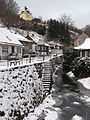
Wieda is on River Wieda , a tributary of River Zorge in the southern part of the Harz mountains
Sights
There are many well-preserved half-timbered houses in the center of Wieda, e.g. in the High Street close to the wooden Town Hall. The Old Clock Tower is on the top of a hill offering a scenic view of the municipality and its surroundings. Lutherkirche is the protestant town church which was built in 1770.[2]
-
Protestant Church
-
Clock Tower
-
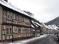
Half-timbered houses in the High Street
-

River Wieda
-
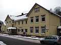
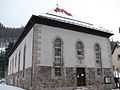
Town Hall
| Wikimedia Commons has media related to Wieda. |
| |||||||
References
- ↑ Landesbetrieb für Statistik und Kommunikationstechnologie Niedersachsen, Fortgeschriebene Einwohnerzahlen zum 31. Dezember 2012
- ↑ Ulrich Großmann: Hannover und Südniedersachsen, p. 192. Köln 1999
This article is issued from Wikipedia. The text is available under the Creative Commons Attribution/Share Alike; additional terms may apply for the media files.