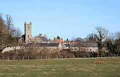
Whittingham, Northumberland
From Wikipedia, the free encyclopedia
Coordinates: 55°23′49″N 1°53′56″W / 55.397°N 1.899°W

| Whittingham | |
 Whittingham Village |
|
 Whittingham | |
| Population | 406 (2001 census)[1] |
|---|---|
| OS grid reference | NU065115 |
| District | Alnwick |
| Shire county | Northumberland |
| Region | North East |
| Country | England |
| Sovereign state | United Kingdom |
| Post town | ALNWICK |
| Postcode district | NE66 |
| Dialling code | 01665 |
| Police | Northumbria |
| Fire | Northumberland |
| Ambulance | North East |
| EU Parliament | North East England |
| UK Parliament | Berwick-upon-Tweed |
| |
| River Aln Settlements |
|---|
Whittingham is a village and civil parish in Northumberland, England. It is situated on the banks of the River Aln, roughly 4.5 miles (7 km) east of its source at Alnham and 7.3 miles (12 km) west of Alnwick.

Whittingham Tower
The thirteenth/fourteenth century pele tower, Whittingham Tower, was converted into almshouses in 1845 and is now in private ownership.
Governance
Whittingham is in the parliamentary constituency of Berwick-upon-Tweed.
References
External links
| Wikimedia Commons has media related to Whittingham, Northumberland. |
This article is issued from Wikipedia. The text is available under the Creative Commons Attribution/Share Alike; additional terms may apply for the media files.