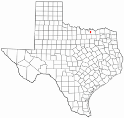
Whitesboro, Texas
| Whitesboro, Texas | |
|---|---|
| City | |
 | |
 | |
| Coordinates: 33°39′35″N 96°54′22″W / 33.65972°N 96.90611°WCoordinates: 33°39′35″N 96°54′22″W / 33.65972°N 96.90611°W | |
| Country | United States |
| State | Texas |
| County | Grayson |
| Area | |
| • Total | 3.2 sq mi (8.3 km2) |
| • Land | 3.2 sq mi (8.3 km2) |
| • Water | 0.0 sq mi (0.0 km2) |
| Elevation | 820 ft (250 m) |
| Population (2000) | |
| • Total | 3,760 |
| • Density | 1,179.9/sq mi (455.1/km2) |
| Time zone | Central (CST) (UTC-6) |
| • Summer (DST) | CDT (UTC-5) |
| ZIP code | 76273 |
| Area code(s) | 903 |
| FIPS code | 48-78532[1] |
| GNIS feature ID | 1371458[2] |
| Website | www.WhitesboroTexas.com |
Whitesboro is a city in Grayson County, Texas, United States. The population was 3,793 at the 2010 census. Whitesboro is named for its founder, Ambrose B. White.
It is part of the Sherman–Denison Metropolitan Statistical Area.
Prominent Houston attorney Joe Rollins (1918–2008) practiced law in Whitesboro in the 1950s.
History
The first settler in the area was Robert Diamond but beginning of the settlement of Wolfpath began with the arrival of Ambrose B. White and his family in 1848. The Butterfield Overland Mail route used White's Westview Inn as its Davidson Station on its trail from the Mississippi River to the Pacific Coast from 1858 to 1861. A post office, under the name Whitesborough, began operations there in 1860.
After the Civil War, Whitesborough grew into a frontier town where female residents were prohibited from leaving their homes on Saturday nights because shootings were so common. Whitesborough had a population of 500, saloons, several stores, and other businesses when it was incorporated on June 2, 1873. By 1879, it had a bank, a newspaper, and train service from Denison, Texas on a line from the Missouri, Kansas and Texas Railroad. In 1887, it altered the spelling of its name to Whitesboro.[3]
Geography
Whitesboro is located at 33°39′35″N 96°54′22″W / 33.65972°N 96.90611°W (33.659612, -96.905999)[4]. Most of the city lies in Grayson County.
According to the United States Census Bureau, the city has a total area of 3.2 square miles (8.3 km2), all of it land.
Demographics
As of the census[1] of 2000, there were 3,760 people, 1,508 households, and 1,040 families residing in the city. The population density was 1,179.9 people per square mile (455.1/km²). There were 1,624 housing units at an average density of 509.6/sq mi (196.6/km²). The racial makeup of the city was 96.57% White, 0.19% African American, 0.77% Native American, 0.40% Asian, 0.03% Pacific Islander, 1.09% from other races, and 0.96% from two or more races. Hispanic or Latino of any race were 2.95% of the population.
There were 1,508 households out of which 33.4% had children under the age of 18 living with them, 53.3% were married couples living together, 12.5% had a female householder with no husband present, and 31.0% were non-families. 28.0% of all households were made up of individuals and 15.9% had someone living alone who was 65 years of age or older. The average household size was 2.44 and the average family size was 2.97.
In the city the population was spread out with 26.3% under the age of 18, 7.1% from 18 to 24, 26.3% from 25 to 44, 20.1% from 45 to 64, and 20.2% who were 65 years of age or older. The median age was 38 years. For every 100 females there were 87.0 males. For every 100 females age 18 and over, there were 82.4 males.
The median income for a household in the city was $31,296, and the median income for a family was $43,150. Males had a median income of $30,165 versus $22,991 for females. The per capita income for the city was $15,865. About 8.5% of families and 12.2% of the population were below the poverty line, including 16.2% of those under age 18 and 11.7% of those age 65 or over.There is still relatives of Ambros white living in whitesboro
Education
The City of Whitesboro is served by the Whitesboro Independent School District.
References
- ↑ 1.0 1.1 "American FactFinder". United States Census Bureau. Retrieved 2008-01-31.
- ↑ "US Board on Geographic Names". United States Geological Survey. 2007-10-25. Retrieved 2008-01-31.
- ↑ Brian Hart, "WHITESBORO, TX," Handbook of Texas Online (http://www.tshaonline.org/handbook/online/articles/hgw09), accessed May 28, 2011. Published by the Texas State Historical Association.
- ↑ "US Gazetteer files: 2010, 2000, and 1990". United States Census Bureau. 2011-02-12. Retrieved 2011-04-23.
External links
| ||||||||||||||||||||||||||
