Whifflet

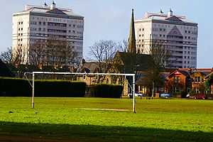
Whifflet (Scots: The Whufflit, Scottish Gaelic: Magh na Cruithneachd)[1] is now a suburb of Coatbridge, Scotland, which once formed its own distinctive village. It is referred to locally as 'The Whifflet' (and pronounced wheeflet). Presently located in the North Lanarkshire Council area it was originally known as wheat flats (hence the vernacular pronunciation) but over time the name appears to have developed into Whifflet. It is dominated by its main street, Whifflet Street, which has many shops including an old sweet shop Tommy Tangos, pubs and bookmakers and is towered over by the post-war built Calder flats. The two most prominent tower blocks are on Whifflet St.
Whifflet has been an area of Coatbridge which has historically been the centre of much mining activity. One of the Whifflet pits in the 19th century reached a depth of 330 feet underground.[2]
Albion Rovers were originally based in the Whifflet area at Meadow Park (now an electric substation next to the rail line).[3]
Notable residents have included Jock Cunningham a Coatbridge miner, mutineer and brigade commander on the republican side during the Spanish civil war who lived at number 77b Whifflet Street.
In 1968, Robert Plant and John Bonham, before forming Led Zeppelin, did a Scottish tour with group Band of Joy in which they played the Marion Hall in Whifflet.
Whifflet has a long sealed 400 metre long tunnel running south from the Calder Street traffic lights which was once part of a rail line.
Whifflet railway station provides travel links to Glasgow, Motherwell, Coatbridge, and Cumbernauld.
References
- ↑ List of railway station names in English, Scots and Gaelic – NewsNetScotland
- ↑ Coatbridge: Three Centuries of Change – Peter Drummond and James Smith, Monkland Library Services, 1982 p.23
- ↑ Coatbridge: Three Centuries of Change – Peter Drummond and James Smith, Monkland Library Services, 1982 p.36
Coordinates: 55°51′14″N 4°01′02″W / 55.85389°N 4.01722°W
External links
| Find more about Whifflet at Wikipedia's sister projects | |
| |
Definitions and translations from Wiktionary |
| |
Media from Commons |
| |
Quotations from Wikiquote |
| |
Source texts from Wikisource |
| |
Textbooks from Wikibooks |
| |
Learning resources from Wikiversity |