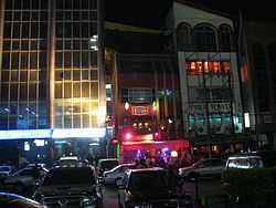
Westlands
| Westlands | |
|---|---|
 | |
| Nickname(s): Westie | |
 Westlands | |
| Coordinates: 01°16′12″S 36°48′36″E / 1.27000°S 36.81000°E | |
| Country |
|
| County | Nairobi County |
| City | Nairobi |
| Elevation | 5,600 ft (1,700 m) |
Westlands is an affluent neighbourhood in the city of Nairobi, the capital and largest city in Kenya.
Overview
Located 3.1 kilometres (1.9 mi) by road northwest of the central business district of Nairobi,[1] Westlands was a residential district during the colonial period which ended in 1963. During the 1990s and early 2000s, as land and office space became scarce and exorbitantly priced in the central business district, more businesses have relocated to Westlands and Upper Hill, where land and office space are more readily available and less expensive. Westlands was initially considered part of the Parklands area and straddled what is now Waiyaki Way, originally the Kenya-Uganda Railway. The area has been nicknamed Westie by the youth of Nairobi. It is nowadays typically inhabitted by a significant number of the city's expat population.
Population
The population of Westlands is not publicly known, as of November 2010.
Landmarks
In Westlands or near the boundaries of the neighbourhood, there are several landmarks, including the following:
- The Sarit Centre Shopping Mall
- The Nakumatt Ukay Shopping Mall
- The Westgate shopping mall
- The M.P.Shah Hospital – A private hospital
- Unga House – An office high-rise building
- Mpaka Road – Many businesses have offices on this street
- USAID Towers – The headquarters of USAID in Kenya
- The High Commission of Botswana to Kenya
- The Embassy of Norway to Kenya
- The Embassy of Sweden to Kenya
- Westlands Office Park
- Westlands Primary School
- A branch of ABC Bank (Kenya)
- A branch of Catholic Relief Services
- A branch of Commercial Bank of Africa
- A branch of Equatorial Commercial Bank
- A branch of FidelityBank
- A branch of First Community Bank
- A branch of Giro Commercial Bank
- A branch of Guardian Bank
- A branch of I&M Bank
- A branch of NIC Bank
- The main branch of Oriental Commercial Bank
- The main branch of Paramount Universal Bank
- A branch of Postbank Kenya
- A branch of Prime Bank (Kenya)
- A branch of Standard Chartered Bank
- A branch of Woolworth Stores
- The Nairobi Institute of Technology
- Frepac Tech (The headquarters)
Westlands division
Apart from being a commercial centre, Westlands is also one of the eight administrative divisions in Nairobi. The division consists of the following six subdivisions (locations):
Westlands is also an electoral constituency, the Westlands Constituency. It has the same borders with Westlands division.
Deep Sea Settlement
Within the Westlands division lies the Deep Sea Settlement. This is a shanty town of approximately 7,000 inhabitants. In 2005 a private firm, with police support, began bulldozing homes, an act the Kenyan high court deemed illegal, due to a law allowing people land rights after squatting there for more than 12 years. Combined with this land-rights issue, poverty is rife and is exacerbated by the area's poor sanitation.[2] [3]
External links
See also
References
- ↑ Road Distance Between Nairobi Central And Westlands With Map
- ↑ Amnesty International UK: Deep Sea Settlement – Kenya, retrieved 2009-08-31
- ↑ Kenya Broadcasting Corporation: Uhuru presents ambitious budget, retrieved 2009-08-31
| ||||||||||
Coordinates: 01°16′12″S 36°48′36″E / 1.27000°S 36.81000°E
