Western Tatras
| Western Tatras | |
|---|---|
| Slovak: Západné Tatry | |
 Western Tatras in winter | |
| Highest point | |
| Peak | Bystrá |
| Elevation | 2,248.4 m (7,377 ft) |
| Geography | |
| Countries | Slovakia and Poland |
| State/Province |
Žilina Lesser Poland |
| Range coordinates | 49°12′N 19°45′E / 49.2°N 19.75°ECoordinates: 49°12′N 19°45′E / 49.2°N 19.75°E |
| Parent range | Tatra Mountains |
| Borders on | Eastern Tatras |
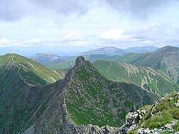


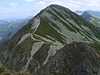
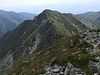
The Western Tatras (Slovak: Západné Tatry; Polish: Tatry Zachodnie) are mountains in the Tatras, part of the Carpathian Mountains, located on the Polish-Slovak borders. The mountains border the High Tatras in the east, Podtatranská kotlina in the south, Choč Mountains in the west and Rów Podtatrzański (Slovak: Podtatranská brázda) in the north. The main ridge is 37 kilometers long and the mountain range contains 31 two-thousanders.
Western Tatras are the second highest mountain range in Slovakia; its highest peak is Bystrá at 2,248 meters. Other notable mountains include Jakubiná (2,194 m), Baranec (2,184 m), Baníkov (2,178 m), Tri kopy (2,136.3 m), Plačlivé (2,125.1 m), Ostrý Roháč (2,087.5 m), Volovec (Polish: Wołowiec; 2,064 m), Kasprowy Wierch (Slovak: Kasprov vrch; 1,987 m) and Giewont (1,894 m). In Slovakia, they are partially located in the traditional regions of Liptov and Orava. The highest point in Poland is Starorobociański Wierch (2,176 m).
All visitors to the Western Tatras area are obliged since July 1, 2006 to cover all costs of their rescue by the Mountain Rescue Service. Visitors are prohibited from leaving the marked tourist routes, sleeping in the mountains or setting fire are strictly prohibited.
Division
The Western Tatras are subdivided into 6 regions on the Slovak side and 4 on the Polish side.
Slovak Western Tatras:
- Osobitá (highest point: Osobitá, 1 687 m)
- Sivý vrch (highest point: Sivý vrch, 1 805 m)
- Liptovské Tatry (highest point: Bystrá, 2 248 m)
- Roháče (highest point: Baníkov, 2 178 m)
- Červené vrchy (highest point: Kresanica / Krzesanica, 2 122 m)
- Liptovské kopy (highest point: Veľká kopa, 2 122 m)
Polish Western Tatras:
- Grześ
- Kasprowy Wierch
- Czerwone Wierchy (corresponds to Červené vrchy, highest point: Kresanica / Krzesanica, 2 122 m)
- Ornak
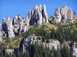
Geology and ecology
The Western Tatras are protected by Tatranský národný park in Slovakia and Tatrzański Park Narodowy in Poland.
Peaks
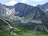
The following is a list of the highest 10 of the 31 two-thousanders in Western Tatras:
| Image | Slovak name | Polish name | Height | Location & Notes |
|---|---|---|---|---|
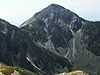
 | Bystrá | Bystra | 2 248,4 m | Liptovské Tatry, the highest peak in Slovak Western Tatras |
 | Jakubiná | Raczkowa Czuba | 2 193,7 m | |
 | Baranec | Baraniec | 2 184,6 m | |
 | Baníkov | Banówka | 2 178 m | Highest point on the main ridge |
 | Klin | Starorobociański Wierch | 2 176 m | Main ridge, the highest peak in Polish Western Tatras |
 | Pachoľa | Pachola | 2 167 m | Main ridge |
 | Hrubá kopa | Hruba Kopa | 2 166 m | Main ridge |
 | Blyšť | Błyszcz | 2 159 m | Bystrá ridge |
 | Príslop | Jałowiecki Przysłop | 2 142 m | |
 | Hrubý vrch | Jarząbczy Wierch | 2 137 m |
Saddles (cols)
- Pálenica (1 570 m)
- Parichvost (1 870 m)
- Baníkovské sedlo (2 045 m)
- Smutné sedlo (1 965 m)
- Žiarske sedlo (1 917,1 m)
- Jamnícke sedlo (1 908 m)
- Račkovo sedlo (1 958 m)
- Gáborovo sedlo (1 890 m)
- Bystré sedlo (1 960 m)
- Pyšné sedlo (1 791,6 m)
- Tomanovské sedlo (1 685,9 m)
- Ľaliové sedlo (1 951,8 m)
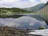
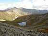
Tarns
There are approximately 20 to 32 tarns (Slovak: pleso) in Western Tatras. The exact number is difficult to obtain because of lack of an exact definition and because it is sometimes hard to prove what is a tarn and what is not. The following is a list of 15 largest tarns in Western Tatras:
| Image | Slovak name | Polish name | Height (m) | Area (ha) | Depth (m) |
|---|---|---|---|---|---|
 | Dolné Roháčske pleso | Niżni Staw Rohacki | 1 563 | 2,22 | 6,3 |
 | Horné Roháčske pleso | Wyżni Staw Rohacki | 1 718 | 1,45 | 8,1 |
 | Dolné Jamnícke pleso | Niżni Jamnicki Staw | 1 728 | 1,13 | 4,0 |
_a1.jpg) | Horné Bystré pleso | Wielki Staw Bystry | 1 875 | 0,86 | 12,5 |
 | Horné Račkovo pleso | Zadni Staw Raczkowy | 1 717 | 0,74 | 10,0 |
| | Tretie Roháčske pleso | Pośredni Rohacki Staw | 1 653 | 0,61 | 3,7 |
 | Horné Jamnícke pleso | Wyżni Jamnicki Staw | 1 834 | 0,41 | 8,0 |
 | Spodné Bystré pleso | Niżni Staw Bystry | 1 837 | 0,34 | 4,0 |
 | Pleso pod Zverovkou | Stawek pod Zwierówką | 983 | 0,31 | 1,2 |
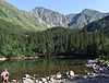 | Ťatliakovo pleso | Czarna Młaka | 1 370 | 0,28 | 1,2 |
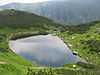 | Druhé Roháčske pleso | Mały Rohacki Staw | 1 650 | 0,28 | 1,3 |
| Horné Tomanovo pleso | Wyżni Tomanowy Stawek | 1 592 | 0,19 | 1,0 | |
| Žiarske pleso | 1 860 | 0,11 | 0,8 | ||
 | Kobylie pleso | Kobyli Stawek | 1 742 | 0,10 | 1,5 |
 | Biele Bobrovecké pleso | Biały Stawek Bobrowiecki | 1 502 | 0,10 | 1,5 |
Caves
- Jaskinia Wielka Śnieżna, the largest and deepest cave in Poland
- Brestovská cave, uniquely features an underground river (not accessible to the public)[1]
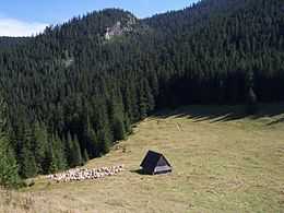
Tourism
There are four tourist centers inside the Western Tatras area: Zverovka, Brestová and Ťatliakova chata in the northern region and Žiarska chata in the southern region. All other tourist centers lie at the outside borders of the mountains, including: Oravice, Zuberec, Bobrovecká vápenica, Žiar, Konská, Jakubovany-Studená dolina, Pribylina, Podbanské.
See also
- Eastern Tatras – mountain range bordering the Western Tatras in the east
- Mountain Rescue Service (Slovakia)
- Tourism in Slovakia
| Wikimedia Commons has media related to Western Tatras. |
References
Sources
- Touristic map 1:25000 Západné Tatry - Podbanské - Zverovka, VKÚ a.s. Harmanec, 2008