West Bay (Texas)
| West Bay | |
|---|---|
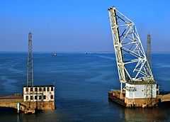
 The old Galveston Causeway, crossing West Bay | |
| Location | Texas Gulf Coast |
| Coordinates | 29°15′25″N 94°57′57″W / 29.257049°N 94.96582°W |
| Ocean/sea sources | Gulf of Mexico |
| Basin countries | United States |
| Settlements | Jamaica Beach, Tiki Island |
West Bay, also referred to as West Galveston Bay,[1] is a long inlet of Galveston Bay in Galveston and Brazoria counties that nearly runs the entire length west of Galveston Island.
History
West Bay, as it is known today, began its formation about 5,500 years ago when Galveston Island was shaped following the rise in the sea level. At the time, West Bay was situated just north of the mouth of the Brazos River, which formed a delta at what is now San Luis Pass. Three thousand years later, the river diverted south to its present location at Surfside Beach. The bay's current formation was complete by about 1,200 years ago.[2]
The main settlements on the bay include Tiki Island located at the mainland base of the Galveston Causeway, and Jamaica Beach on Galveston Island, just south of Galveston Island State Park. Jamaica Beach, a resort with a population of about 1,075 was found in 1957 on the site of a former Karankawa Indian burial ground.[3] Across the bay from Jamaica Beach is Tiki Island, an affluent[4] village of 1,016 people, that was established in the 1960s and incorporated in 1982.[5]
Features
West Bay is bounded by San Luis Pass to its south, and Galveston Causeway to the north, where it meets with Galveston Bay. West Bay's main extension is Christmas Bay, which extends south into Brazoria National Wildlife Refuge.[6] Other extensions include, Chocolate Bay to the west, Jones Bay to the north, and Bastrop Bay to the south. Overall, the bay covers roughly 39 square miles (100 km2).[7]
References
- ↑ Kleiner, Diana J. (May 30, 2010). "Galveston Island State Park". Handbook of Texas Online. Texas State Historical Association. Retrieved 21 June 2010.
- ↑ Anderson, John B. (May 2007). The formation and future of the upper Texas coast: a geologist answers questions about sand, storms, and living by the sea. Texas A&M University Press. p. 43. ISBN 978-1-58544-561-5.
- ↑ Kleiner, Diana J. (May 30, 2010). "Jamaica Beach, Texas". Handbook of Texas Online. Texas State Historical Association. Retrieved 21 June 2010.
- ↑ "Tiki Island, Texas". City-data. Retrieved 21 June 2010.
- ↑ Jasinski, Laurie E. (May 30, 2010). "Village of Tiki Island, Texas". Handbook of Texas Online. Texas State Historical Association. Retrieved 21 June 2010.
- ↑ Leatherwood, Art (May 30, 2010). "West Bay". Handbook of Texas Online. Texas State Historical Association. Retrieved 21 June 2010.
- ↑ Engineers, United States. Army. Corps of (1908). Report of the Chief of Engineers United States Army. U.S. Govt. Print. Off. p. 356.
Coordinates: 29°15′25″N 94°57′57″W / 29.257049°N 94.96582°W