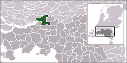
Werkendam
From Wikipedia, the free encyclopedia
| Werkendam | |||
|---|---|---|---|
| Municipality | |||
 | |||
| |||
 | |||
| Coordinates: 51°49′N 04°54′E / 51.817°N 4.900°ECoordinates: 51°49′N 04°54′E / 51.817°N 4.900°E | |||
| Country | Netherlands | ||
| Province | North Brabant | ||
| Region | Land van Heusden en Altena | ||
| Area(2006) | |||
| • Total | 121.73 km2 (47.00 sq mi) | ||
| • Land | 105.00 km2 (40.54 sq mi) | ||
| • Water | 16.73 km2 (6.46 sq mi) | ||
| Population (1 January 2007) | |||
| • Total | 26,523 | ||
| • Density | 253/km2 (660/sq mi) | ||
| Source: CBS, Statline. | |||
| Time zone | CET (UTC+1) | ||
| • Summer (DST) | CEST (UTC+2) | ||
| Website | www.werkendam.nl | ||
Werkendam (![]() pronunciation (help·info)) is a municipality and a town in the southern Netherlands. The municipality contains a large part of De Biesbosch area.
pronunciation (help·info)) is a municipality and a town in the southern Netherlands. The municipality contains a large part of De Biesbosch area.
Population centres
- Dussen
- Hank
- Nieuwendijk
- Sleeuwijk
- 't Zand
- Werkendam
Topography

Dutch Topographic map of the municipality of Werkendam, 2013.
Transport
Public transport is by Veolia neighborhood bus to Gorinchem through Sleeuwijk Tol, and by ferry to Boven-Hardinxveld.[1] The bus between Utrecht and Breda, and the bus between Gorinchem and Den Bosch goes through Sleeuwijk Tol.
For road traffic to Dordrecht there is a ferry to cross the Nieuwe Merwede river.[1]
References
- ↑ 1.0 1.1 (Dutch) www.voetveren.nl
External links
-
 Media related to Werkendam at Wikimedia Commons
 - (Dutch) Official Website
 |
Hardinxveld-Giessendam (ZH) Boven Merwede |
Gorinchem (ZH) Boven Merwede |
 | |
| Dordrecht (ZH) / Nieuwe Merwede | |
Woudrichem Aalburg | ||
| ||||
| | ||||
| Drimmelen | Geertruidenberg | Waalwijk |
This article is issued from Wikipedia. The text is available under the Creative Commons Attribution/Share Alike; additional terms may apply for the media files.


