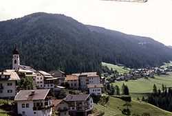
Welschnofen
| Welschnofen | |
|---|---|
| Comune | |
| Gemeinde Welschnofen Comune di Nova Levante | |
 | |
 Welschnofen | |
| Coordinates: 46°26′N 11°33′E / 46.433°N 11.550°ECoordinates: 46°26′N 11°33′E / 46.433°N 11.550°E | |
| Country | Italy |
| Region | Trentino-Alto Adige/Südtirol |
| Province | South Tyrol (BZ) |
| Government | |
| • Mayor | Markus Dejori |
| Area | |
| • Total | 50.8 km2 (19.6 sq mi) |
| Population (Nov. 2010) | |
| • Total | 1,910 |
| • Density | 38/km2 (97/sq mi) |
| Demonym |
German: Welschnofner Italian: novalevantini |
| Time zone | CET (UTC+1) |
| • Summer (DST) | CEST (UTC+2) |
| Postal code | 39056 |
| Dialing code | 0471 |
| Website | Official website |
Welschnofen (Italian: Nova Levante) is a comune (municipality) in the autonomous province of South Tyrol in northern Italy, located about 15 km southeast of the city of Bolzano.
Geography
As of November 30, 2010, it had a population of 1,910 and an area of 50.8 km².[1]
Welschnofen borders the following municipalities: Karneid, Moena, Deutschnofen, Pozza di Fassa, Predazzo, Tiers, and Vigo di Fassa.
History
Coat-of-arms
The escutcheon is party per quarterly: the 1st and the 4th represent an or rampant lion on sable, the arms of the Judge Bartlmä von Pretzenberg which has had an estate in the municipality. In the 2nd and 3rd quarter an azure mountain is surmounted by an argent pretzels on gules. The emblem was adopted in 1967.[2]
Society
Linguistic distribution
According to the 2011 census, 94.00% of the population speak German, 5.53% Italian and 0.47% Ladin as first language.[3]
Demographic evolution

References
- ↑ All demographics and other statistics: Italian statistical institute Istat.
- ↑ Heraldry of the World: Welschnofen
- ↑ "Volkszählung 2011/Censimento della popolazione 2011". astat info (Provincial Statistics Institute of the Autonomous Province of South Tyrol) (38): 6–7. June 2012. Retrieved 2012-06-14.
External links
![]() Media related to Welschnofen at Wikimedia Commons
Media related to Welschnofen at Wikimedia Commons
- (German) (Italian) Homepage of the municipality
- (English) Rosengarten Latemar
