Wathaurong people
| Regions with significant populations | |
|---|---|
| Languages | |
| Wada wurrung, English | |
| Religion | |
| Australian Aboriginal mythology, Christianity | |
| Related ethnic groups | |
|
Boonerwrung, Dja Dja Wurrung, Taungurong, Wurundjeri see List of Indigenous Australian group names |
Wathaurong, also called the Wada Wurrung, are an Indigenous Australian tribe living in the area near Melbourne, Geelong and the Bellarine Peninsula. They are part of the Kulin alliance. The Wathaurong language was spoken by 25 clans south of the Werribee River and the Bellarine Peninsula to Streatham. They were sometimes referred to by Europeans as the Barrabool people. They have inhabited this area for at least the last 25,000 years with 140 archaeological sites having been found in the region, indicating significant activity over that period.[1]
History
European Settlement
Coastal clans of the Wada Wurrung may have had contact with Lieutenant John Murray when he charted Indented Head and named Swan Bay. Matthew Flinders met several Wada Wurrung when he camped at Indented Head and climbed the You Yangs in May 1802.
When Lieutenant David Collins founded the colony at Sullivan Bay, Victoria in October 1803, he sent Lieutenant J Tuckey to survey and explore Corio Bay which resulted in several Aborigines being shot and wounded. William Buckley, a convict, escaped from the abortive Sullivan Bay settlement in December 1803, and was adopted by the Wada wurrung balug as they thought he was the resurrected Murrangurk, an important former leader. Buckley lived with this community for 32 years, between 1803 and 1835, before making contact with John Batman's expedition on 6 July 1835.[2]
The European settlement of Wada wurrung territory began in earnest from 1835 with a rapid arrival of squatters around the Geelong area and westwards. Settlement was marked by resistance to the invasion often by driving off or stealing sheep which then resulted in conflict and sometimes a massacre of Aboriginal people.[3]
Very few of these reports were acted upon to bring the settlers to court. On the few occasions when this did happen, such as the killing of Woolmudgin on 7 October 1836 where John Whitehead was sent to Sydney for trial, the case was dropped for lack of evidence. At the time Aborigines were denied the right to give evidence in courts of law. The incidents listed below are just the cases that have been reported, it is likely other incidents occurred that were never documented officially. Neil Black, a squatter in Western Victoria writing on 9 December 1839 states the prevailing attitude of many settlers:
- "The best way [to procure a run] is to go outside and take up a new run, provided the conscience of the party is sufficiently seared to enable him without remorse to slaughter natives right and left. It is universally and distinctly understood that the chances are very small indeed of a person taking up a new run being able to maintain possession of his place and property without having recourse to such means -- sometimes by wholesale..."[4]
Table: reported aboriginal killings in Wada wurrung territory to 1859[5]
| Date | Location | Aborigines involved | Europeans involved | Aboriginal Deaths reported |
|---|---|---|---|---|
| October 1803 | Corio Bay | Wada wurrung, possibly Yaawangi or Wada wurrung balug | Lieutenant J Tuckey and others | two people |
| 17 October 1836 | Barwon River, Barrabool Hills | Wada wurrung balug clan | John Whitehood, encouraged by Frederick Taylor | Woolmudgin alias Curacoine |
| Summer 1837-1838 | Golf Hill Station, Yarrowee River, north of Inverleigh | Wada wurrung clan unknown | A shepherd and a hut keeper, Clyde company employees | two people |
| June 1839 – 1840 | unknown | Wada wurrung balug clan | soldiers | three people |
| 25 November 1847 | Anderson and Mills Public House, Buninyong | Wada wurrung clan unknown | unknown | two people |
Aboriginal presence on the Ballarat goldfields
Historian Ian D. Clark has written on the Aboriginal presence on the Ballarat goldfields in the 1850s noting that while there is no evidence for any direct involvement of Aboriginal people in the events of the Eureka Rebellion in 1854, aboriginal people may be relevant to the Eureka story in situational, contextual and relational ways.[6]
The events of the Eureka Rebellion took place on Wathaurong aboriginal land. Three Wathaurong clans lived in the vicinity of the Eureka diggings: the Burrumbeet baluk at Lakes Burrumbeet and Learmonth, Keyeet baluk, a sub-group of the Burrumbeet baluk, at Mt Buninyong, and the Tooloora baluk, at Mt Warranheip and Lal Lal Creek.[6] There are numerous accounts of aboriginal presence in tha Ballarat area during the 1850s.[6]
The early policing of the Ballarat Goldfields was done by the Native Police Corps, who enforced the collection of the gold miners licence fee resulting in confrontations between diggers and the Gold Commissioner, considered by some historians such as M. Cannon and Weston Bate as preludes to the 1854 Eureka Rebellion.[6]
There is oral history that local aboriginal people may have looked after some of the children of the Eureka miners after the military storming of the Eureka Stockade and subsequent massacre of miners. Although not corroborated by any written sources, the account has been deemed plausible by Professor Clark.[6]
Some further credence, although circumstantial, may be provided to the above information. George Yuille, older brother to William Cross Yuille was not only liked and trusted by the local aboriginals but also had formed a relationship with one of the women. Together they had at least one child also named George Yuille. George Yuille senior died on the 26 Mar 1854. He was at the time of his death a storekeeper on Specimen Hill and hence he was among the miners. As to whether his aboriginal wife was with him is unknown but it is a fair assumption that the local aboriginals would have been very familiar with the miners especially if they were in constant contact with George Yuille.
Structure, Borders and Land Use
Communities consisted of 25 land-owning groups called clans that spoke a related language and were connected through cultural and mutual interests, totems, trading initiatives and marriage ties. Access to land and resources by other clans, was sometimes restricted depending on the state of the resource in question. For example; if a river or creek had been fished regularly throughout the fishing season and fish supplies were down, fishing was limited or stopped entirely by the clan who owned that resource until fish were given a chance to recover. During this time other resources were utilised for food. This ensured the sustained use of the resources available to them. As with most other Kulin territories, penalties such as spearings were enforced upon trespassers. Today, traditional clan locations, language groups and borders are no longer in use and descendants of Wathaurong people live within modern day society, although still preserving much of their culture.
Territory
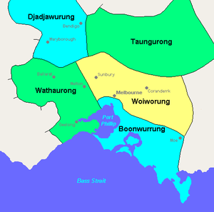
The Wathaurong territory extended from the southern side of the Werribee River to Port Phillip, the Bellarine Peninsula, the Otway forests,and northwest to Mount Emu and Mount Misery. Their territory encompassed the Ballarat goldfields.
Clans
Prior to European settlement, 25 separate clans existed, each with an arweet, or clan headman.[7] Arweet held the same tribal standing as a ngurungaeta of the Wurundjeri people.
| No | Clan Name | Approximate Location |
|---|---|---|
| 1 | Barere barere balug | 'Colac' and 'Mt Bute' stations |
| 2 | Beerekwart balug | Mount Emu |
| 3 | Bengalat balug | Indented Head |
| 4 | Berrejin balug | Unknown |
| 5 | Boro gundidj | Yarrowee River |
| 6 | Burrumbeet gundidj | Lakes Burumbeet and Learmonth |
| 6a | Keyeet balug | Mount Buninyong |
| 7 | Carringum balug | Carngham |
| 8 | Carininje balug | 'Emu Hill' station, Linton's Creek |
| 9 | Corac balug | 'Commeralghip' station, and Kuruc-a-ruc Creek |
| 10 | Corrin corrinjer balug | Carranballac |
| 11 | Gerarlture balug | West of Lake Modewarre |
| 12 | Marpeang balug | Blackwood, Myrniong, and Bacchus Marsh |
| 13 | Mear balug | Unknown |
| 14 | Moijerre balug | Mount Emu Creek |
| 15 | Moner balug | 'Trawalla' station, Mount Emu Creek |
| 16 | Monmart | Unknown |
| 17 | Neerer balug | Between Geelong and the You Yangs (Hovells Ck?) |
| 18 | Pakeheneek balug | Mount Widderin |
| 19 | Peerickelmoon balug | Near Mount Misery |
| 20 | Tooloora balug | Mount Warrenheip, Lal-lal Creek, west branch of Moorabool River. |
| 21 | Woodealloke gundidj | Wardy Yalloak River, south of Kuruc-a-ruc Creek |
| 22 | Wada wurrung balug | Barrabool Hills |
| 23 | Wongerrer balug | Head of Wardy Yalloak River |
| 24 | Worinyaloke balug | West side of Little River |
| 25 | Yaawangi | You Yang Hills |
External links
References
- ↑ Wathaurong People Geelong City Council website, Accessed November 9, 2008
- ↑ Ian D. Clark, pp169, Scars on the Landscape. A Register of Massacre sites in Western Victoria 1803-1859, Aboriginal Studies Press, 1995 ISBN 0-85575-281-5
- ↑ Ian D. Clark, pp169-175, Scars on the Landscape. A Register of Massacre sites in Western Victoria 1803-1859, Aboriginal Studies Press, 1995 ISBN 0-85575-281-5
- ↑ Ian D. Clark, pp1, Scars on the Landscape. A Register of Massacre sites in Western Victoria 1803-1859, Aboriginal Studies Press, 1995 ISBN 0-85575-281-5
- ↑ Ian D. Clark, pp169-175, Scars on the Landscape. A Register of Massacre sites in Western Victoria 1803-1859, Aboriginal Studies Press, 1995 ISBN 0-85575-281-5 Information condensed from descriptive using reports from historical sources
- ↑ 6.0 6.1 6.2 6.3 6.4 Ian D. Clark, Another Side of Eureka - the Aboriginal presence on the Ballarat goldfields in 1854 - Were Aboriginal people involved in the Eureka rebellion?, Heretic Press, working paper 2005/2007, accessed 1 November 2011
- ↑ Ian D. Clark, Aboriginal Languages and Clans: An historical atlas of western and central Victoria, 1990 as referenced in Aboriginal Heritage Wada wurrung Culture and History Our Precious Heritage website, Accessed November 9, 2008
| |||||||||||||||||||||||||||||