Waterpocket Fold
From Wikipedia, the free encyclopedia
Coordinates: 38°01′18″N 111°07′14″W / 38.02167°N 111.12056°W

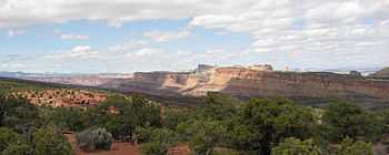
Waterpocket Fold – Looking south from the Strike Valley Overlook

Aerial view of Waterpocket Fold
The Waterpocket Fold is a geologic landform that defines Capitol Reef National Park in the western United States. This monoclinal fold extends for slightly over 100 miles in the desert of central Utah. It can be seen via three scenic routes in the park. One route leads to a famous landmark known as the Golden Throne. This landmark is covered in golden sandstone that gives it its name. The Waterpocket Fold lies east of the town of Torrey, three miles west and just southeast of the Middle Desert. This area is prized for its scenic hiking.
See also
External links
- Photo gallery of the Fold
- Geologic Maps and Images of the Waterpocket Fold, Remote sensing tutorial at USGS
West face of Waterpocket fold – Looking north from Miners Mountain
This article is issued from Wikipedia. The text is available under the Creative Commons Attribution/Share Alike; additional terms may apply for the media files.