Watergang
From Wikipedia, the free encyclopedia
| Watergang | |
|---|---|
| Town | |
 | |
 | |
| Coordinates: 52°26′N 4°57′E / 52.433°N 4.950°ECoordinates: 52°26′N 4°57′E / 52.433°N 4.950°E | |
| Country | Netherlands |
| Province | North Holland |
| Municipality | Waterland |
| Population | |
| • Total | 420 |
| Time zone | CET (UTC+1) |
| • Summer (DST) | CEST (UTC+2) |

Watergang, church in the street
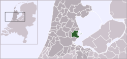
Watergang (![]() pronunciation (help·info), literally "watercourse") is a village in the northwest Netherlands. It is located in the municipality of Waterland, North Holland, about seven kilometres (four miles) north of Amsterdam, on the east bank of the Noordhollandsch Kanaal.
pronunciation (help·info), literally "watercourse") is a village in the northwest Netherlands. It is located in the municipality of Waterland, North Holland, about seven kilometres (four miles) north of Amsterdam, on the east bank of the Noordhollandsch Kanaal.
In 2001, the village of Watergang had 217 inhabitants. The built-up area of the town was 0.08 km², and contained 83 residences.[1] The wider statistical area of Watergang has a population of around 420.[2]
References
- ↑ Statistics Netherlands (CBS), Bevolkingskernen in Nederland 2001 . Statistics are for the continuous built-up area.
- ↑ Statistics Netherlands (CBS), Gemeente Op Maat 2004: Waterland .
This article is issued from Wikipedia. The text is available under the Creative Commons Attribution/Share Alike; additional terms may apply for the media files.