Wasgau
| Wasgau | |
|---|---|
 Typical Wasgau countryside with conical hills and plains: view looking southwest from Rehberg | |
| Highest point | |
| Peak | Grand Wintersberg (581 m above NHN) for the whole Wasgau; Rehberg (577 m above NHN) for the German part |
| Dimensions | |
| Area | 1,300 km2 (500 sq mi) |
| Geography | |
<div style="padding:2px 2px 5px 2px;>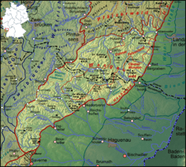 | |
| State | Rhineland-Palatinate (Germany); Départements of Bas-Rhin and Moselle (France) |
| Range coordinates | 49°03′N 7°40′E / 49.05°N 7.66°ECoordinates: 49°03′N 7°40′E / 49.05°N 7.66°E |
| Parent range | of the Palatine Forest (south) and the Vosges (north) |
| Geology | |
| Period |
Bunter sandstone 251–243 M years ago Zechstein 256–251 M years ago |
| Type of rock | Rock units bunter sandstone and Zechstein |
The Wasgau (German: Wasgau, French: Vasgovie) is a Franco-German hill range in the German state of Rhineland-Palatinate and the French departments of Bas-Rhin and Moselle. It is formed from the southern part of the Palatine Forest and the northern part of the Vosges mountains, and extends from the River Queich in the north over the French border to the Col de Saverne (German: Zaberner Steige) in the south.
The highest hill in the entire Wasgau is the Grand Wintersberg (581 m above NHN) near Niederbronn-les-Bains in northern Alsace. Next, at 577 m is the only slightly lower Rehberg near Annweiler in the South Palatinate, which is the highest summit on German soil.
The Wasgau forms the southern part of the Palatine Forest-North Vosges Biosphere Reserve.
Geography
Location
The Wasgau runs from a line between Pirmasens and Landau in the north that, from Wilgartswiesen coincides with the course of the River Queich, to the Col de Saverne and a line between Phalsbourg (German: Pfalzburg) to Saverne (German: Zabern) in the south.[1][2] Its eastern boundary, running from Albersweiler in the Queich valley via Bad Bergzabern, Wissembourg (German: Weißenburg) in Alsace and Niederbronn-les-Bains (German: Bad Niederbronn) to Saverne is the edge of the Rhine Graben. In the west the hills transition smoothly into the landscape region of the Westrich Plateau; from there the younger rock strata of the muschelkalk cover the bunter sandstone that dominates the Wasgau. This natural boundary runs roughly from Pirmasens via Eppenbrunn, Bitche (German: Bitsch) and Lemberg in Lorraine towards the south and, near Phalsbourg, finally reaches the fault zone of the narrow Col de Saverne; this separates the Wasgau from the "real" (North) Vosges immediately to the south, although this transition is rather gradual and the dividing line not particularly clear.[3][4][5][6]
A central sub-region of the Wasgau is the Dahn-Annweilerer-Wasgauer Felsenland, which extends from the Queich valley near Annweiler in the northeast to the area of the Falkensteinerbach stream and Zinsel du Nord (German: Nördliche Zinsel) near Baerenthal (Bärenthal) and Philippsbourg (Philippsburg) in the southwest.
Structure

The uplands of the Wasgau differ from those of the central Palatine Forest that border it to the north. The landscape of the Wasgau has a characteristically variable nature, with numerous conical hills (Kegelberge) as well as clearly rounded domes (Kuppen). Between the hills are conspicuously level plains, some of them extensive.[7]
The Wasgau is drained mostly towards the east by left-hand tributaries of the River Rhine, namely the Queich, the Lauter (called the Wieslauter in its upper reaches) and the Saarbach, which continues as the Sauer in North Alsace. setzt. There it is followed by the Moder, whose catchment area extends southwards via its right-hand tributary, the Zorn, beyond the Col de Saverne.
.jpg)
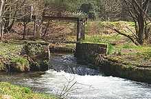
There are no natural lakes in the Wasgau, but especially in the area of the Saarbach stream, historic ponds or woogs have survived from the Middle Ages. These are small lakes that were artificially created to breed fish or to utilize their water in the operation of watermills or iron hammer mills. The water of the Zinsel du Nord near Baerenthal in the Pays de Bitche was used during the 18th and 19th centuries for processing iron in the ironworks and blast furnaces. To that end, several larger and smaller ponds were laid out between Mouterhouse (Mutterhausen) and Baerenthal, which have been mainly used for tourism since the closure of the last ironworks in 1923..[8] Even the Étang de Hanau (Hanauer Weiher), a pond a few miles east of Bitche in Eguelshardt (Egelshardt), has become a major tourist centre with swimming facilities, boat rentals and camping.
Splash dams (Klausen) were constructed, for example on the Wieslauter stream, as part of the timber rafting industry, that was practised until the end of the 19th century. These dams were able to trap logs after temporary flooding which, after the opening of a weir could be transported downstream on the water.
Hills
General


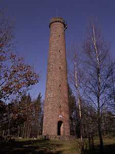
Due to its small-scale relief, the uplands of the Wasgau are characterized by considerable diversity of forms with rather isolated individual peaks - particularly the conical hills or Kegelberge - which reach an average height of 400-500 metres above sea level. The highest peaks are in the northern and central Wasgau (such as the Wegelnburg, 572 m, and the Mohnenberg, 547 m), especially near the edge of the Rhine trough (e.g. the Grand Winterberg, 581 m, and the Rehberg, 577 m), while the bunter sandstone block in the west and south descends from about 500 m (Wasenkoepfel, 526 m and Großer Eyberg, 513 m) to an average of about 350-400 m at the Saverne. Also typical is the number of variably shaped rock formations, mainly rocks of the Lower Triassic sandstone, the Trifels and Rehberg beds, that are found on many hills in the Wasgau (see the sections on Geology and rock formations). In his typology of mountain and rock formations of the Wasgau, Geiger distinguishes the following six forms: hill blocks with rock outcrops, table hills; rock slabs; ridges with rock faces, hill cones with rock blocks; hill cones with rock towers and domed hills.[9] In addition there is a host of hilltop observation towers (e.g. on the Grand Wintersberg, Rehberg, Stäffelsberg and Wasenkoepfel) that offer visitors a 360º panorama.[3][4]
Detailed overview
The columns in the table are based on the Natural Region Division Concept of the Wasgau. Each column shows the important hills of each sub-region in order of height.
| Western Wasgau | Wasgau Felsenland | Eastern Wasgau | Southern Wasgau |
|---|---|---|---|
| Gr. Eyberg (513 m) | Grand Wintersberg (581 m) Ger: Großer Wintersberg |
Hohe Derst (561 m) | Wasenkoepfel (526 m) |
| Gr. Mückenkopf (485 m) | Rehberg (577 m) | Mohnenberg (547 m) | Immenkopf (494 m) |
| Hohe List (476 m) | Wegelnburg (572 m) | Bobenthaler Knopf (534 m) | Arnsberg (479 m) |
| Erlenkopf (472 m) | Hohenbourg (551 m) Ger. Hohenburg |
Brissetischer Kopf (529 m) or Brissetish Kopf |
Mont Saint-Michel (437 m) Ger: Michaelsberg |
| Hoher Kopf (467 m) | Schwobberg (524 m) | Schletterberg (521 m) | Ebersberg (423 m) |
| Braunsberg (463 m) | Maimont (515 m) | Dürrenberg (521 m) | Dürrbergkopf (421 m) |
| Gr. Stephansberg (456 m) | Wasserstein (512 m) | Krummer Ellenbogen (515 m) | Hochfirst (420 m) |
| Hoher Warsberg (451 m) | Engenteich (496 m) | Mittelkopf (515 m) | Käsberg (418 m) |
| Kl. Biesenberg (451 m) | Jüngstberg (491 m) | Treutelsberg (505 m) | Dietrichkopf (415 m) |
-
Observation tower on the Grand Wintersberg (Wasgau Felsenland)
-

The Rehberg and Asselstein (left) (Wasgau Felsenland)
-

The Schlossberg (Wegelnburg) (Wasgau Felsenland)
-
The Schlossberg (Hohenburg) (Wasgau Felsenland): view from the Wegelnburg
-

The Mohnenberg (eastern Wasgau): view from Schöneck Castle
-
The Föhrlenberg (eastern Wasgau): view from the Rehberg
-
View from the Rehberg towards Treutelsberg (eastern Wasgau)
-
The Rothenberg mit Madenburg (eastern Wasgau)
-
The Ebersberg (Wasgau Felsenland): view from the Rehberg
-
View from Saint-Jean-Saverne of Mont Saint-Michel (southern Wasgau)
Geology
Formation and deposition of the rock strata

The Wasgau, as part of the Palatine Forest and the North Vosges, is characterized by rock strata of bunter sandstone and, to a lesser extent, Zechstein, which was deposited in the late Permian (256–251 million years ago) and early Triassic (251–243 million years ago), predominantly under desert-like climatic conditions. Sedimentary sequences were formed with a thickness of about 500 metres, of different strengths, thicknesses and colouring, and comprising mainly strongly hardened, silica-cemented, medium- and coarse-grained sandstones, but also some fine-grained sandstones, bonded with clay cement, and shales. These rocks are divided into various strata that, in the case of the bunter sandstone region, comprise Lower, Middle and Upper levels.[10]
During the formation of the Upper Rhine Graben in the Paleogene period (66–23.8 million years ago), these rock strata experienced tectonically induced displacements that have had a significance impact on the appearance of the landscape of the Wasgau today. At that time the edges of the Rhine Graben were uplifted and the layers of bunter sandstone and, in places also older rocks (Zechstein, Rotliegendes) were exposed after the overlying rock was eroded away. This resulted in tilting, bulging (thrusting and folding) and the fracturing (formation of faults) of the various rock strata.
Sights
Castles
-
Trifels
-
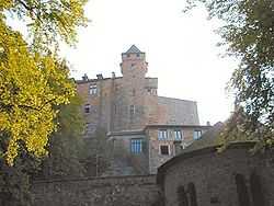
Berwartstein
-

Drachenfels
-
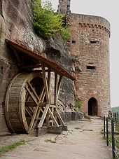
Altdahn
-

View of the Fleckenstein from the Hohenbourg
-

Lichtenberg
Of the numerous castles in the region, several have written history. Trifels Castle, which was partially restored during the 20th century, was where the imperial regalia were kept for a time during the Middle Ages. Together with the castles of Anebos and Scharfenberg, Trifels is the symbol of Annweiler. Berwartstein Castle owned by the legendary knight, Hans von Trotha, called "Hans Trapp", has been restored, is occupied and managed. Drachenfels Castle was destroyed because part of it had belonged to the rebellious knight, Franz von Sickingen. Other castles of the region include (from north to south):
- Lemberg
- Neudahn
- Madenburg
- Castles of Dahn, consisting of Altdahn, Grafendahn and Tanstein
- Landeck
- Lindelbrunn
- Wegelnburg, Hohenbourg and Lœwenstein
- Fleckenstein
- Blumenstein
- Wasigenstein
- Falkenstein
- Wasenbourg
- Lichtenberg
- Hunebourg
Economy and infrastructure
Economy

Iron production and processing, which was important in earlier times (for example, iron smelting in Schönau) came to an end in the late 19th century. A number of so-called Gienanth fountains bear witness to this traditional industry today.
In the 19th and 20th centuries, forestry-related industry and small businesses dominated, especially those involved in shoe manufacturing.
After the Second World War, the shoe industry waned and the economy increasingly turned to tourism, which has now become the main source of income. In addition to mere relaxation, active holidays are offered, for example, climbing in the South Palatinate Climbing Area or hiking. There are several well-maintained cycle paths that mainly follow the valleys in the Wasgau. [11]
Transport

In addition to the main transport artery of the B 10 federal highway along the northern edge of the Wasgau, the region is accessible on the Palatine side in the east from the B 48, from Annweiler to Bad Bergzabern, and in the west and south via the B 427, from Hinterweidenthal via Dahn to Bad Bergzabern. On the other side of the border, the well-developed departement road, the D 662, along the western edge of the Wasgau, links Bitche with Niederbronn-le-Bain and Haguenau (Hagenau) in the Rhine plain. The A 4 motorway from Paris to Strasbourg (Straßburg) and the D 604 cross the Col de Saverne, right in the south of the natural region.
The railway line from Pirmasens to Landau, theQueich Valley Railway which runs parallel to the B 10, was once part of the trunk route between Saarbrücken and Munich, but has been repeatedly downgraded in importance. On the Wieslauter Railway in the west there are excursion services on Sundays and holidays. The line from Saarbrücken via Sarreguemines (Saargemünd) through the valley of the Moder to Strasbourg mainly serves regional traffic. Currently under construction is the TGV link between Paris and Strasbourg, which will cross under the Col de Saverne through a tunnel.
References
- ↑ Emil Knöringer: Der Wasgau mit seinen Felsen und Felsenburgen, S. 14.
- ↑ Karl Heinz: Pfalz mit Weinstraße, pp. 197–199.
- ↑ 3.0 3.1 Landesamt für Vermessung und Geobasisinformation Rheinland-Pfalz (pub.): Topografische Karten 1:25.000 und 1:50.000, abgerufen am 13. Februar 2012.
- ↑ 4.0 4.1 Institut Géographique National (ed.): Cartes Topographiques 1:25.000 und 1:50.000. Paris, verschiedene Jahrgänge.
- ↑ Landesamt für Geologie und Bergbau Rheinland-Pfalz: Geologische Übersichtskarte Rheinland-Pfalz, retrieved 13 February 2012.
- ↑ Bundesanstalt für Landeskunde: Geographische Landesaufnahme. Die naturräumlichen Einheiten in Einzelblättern 1:200.000. Bad Godesberg 1952–1994. → Online-Karten *Blatt 160: Landau i. d. Pfalz (Adalbert Pemöller 1969; 47 pp.).
- ↑ Michael Geiger et al. (ed): Der Pfälzerwald im geographischen Überblick, pp. 40–41.
- ↑ Heinz Wittner et al.: Vogesen – Nord. Deutscher Wanderverlag Dr. Mair & Schnabel & Co., Stuttgart 1983, p. 81.
- ↑ Geiger Michael: Der Pfälzerwald im geographischen Überblick. In: Geiger Michael (ed): Der Pfälzerwald, Porträt einer Landschaft, p. 41.
- ↑ Michael Geiger et al. (ed.): Der Pfälzerwald im geographischen Überblick, pp. 24–29.
- ↑ Rhineland-Palatinate Ministry of Economic Affairs: Welcome to the Rhineland-Palatinate Cycle Wonderland
Literature
- August Becker (2005) (in German), Die Pfalz und die Pfälzer (7th ed.), Landau/Pfalz: Pfälzische Verlagsanstalt, pp. 200–337, ISBN 3898571939
- Rüdiger Bernges (2005) (in German), Felsenburgen im Wasgau (4th ed.), Meckenheim: Warlich Verlag, ISBN 3930376253
- Michael Geiger et al., ed. (1987) (in German), Der Pfälzerwald
- Porträt einer Landschaft, Landau/Pfalz: Verlag Pfälzische Landeskunde, ISBN 3980114716
- Michael Geiger (2010), Michael Geiger, ed., "Die Landschaften der Pfalz" (in German), Geographie der Pfalz (Landau/Pfalz: Verlag Pfälzische Landeskunde): pp. 92–113, ISBN 9783981297409
- Daniel Häberle (1913) (in German), Der Pfälzerwald
- Ein Beitrag zur Landeskunde der Rheinpfalz, Braunschweig und Berlin: Georg Westermann Verlag, pp. 10–32
- Karl Heinz (1976, ASIN B002GZ8RN) (in German), Pfalz mit Weinstraße
- Landschaft, Geschichte, Kultur, Kunst, Volkstum, Heroldsberg: Glock und Lutz Verlag, pp. 191–238
- Emil Heuser (1979, ASIN B0043G3V6M) (in German), Neuer Pfalzführer (14th ed.), Ludwigshafen/Rhein: Waldkirch Verlag
- Emil Knöringer (1985) (in German), Der Wasgau mit seinen Felsen und Felsenburgen (2nd ed.), Landau/Pfalz: Verlag Pfälzer Kunst Dr. Hans Blinn, ISBN 3922580165
- Landesamt für Geologie und Bergbau Rheinland-Pfalz, ed. (2005) (in German), Geologie und Erdgeschichte von Rheinland-Pfalz, Stuttgart: Schweizerbart’sche Verlagsbuchhandlung, ISBN 3510652657
- Kurt Reh (1981, ASIN B0025WB9GK), Michael Geiger et al., ed., "Der Pfälzerwald
- Eine Einführung in Landschaft und Namengebung" (in German), Pfälzische Landeskunde (Landau/Pfalz: Selbstverlag) Vol. 1: pp. 381
- Heinz Wittner (1981) (in German), Großer Pfalzführer, Stuttgart: Deutscher Wanderverlag Dr. Mair & Schnabel, pp. 176–226, ISBN 3813401065
External links
| Wikimedia Commons has media related to Wasgau. |
- Biosphärenreservat Pfälzerwald–Vosges du Nord
- Biosphärenhaus mit Baumwipfelpfad
- Burgenparadies Wasgau
|
.JPG)


