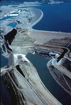
Warsak Dam
| Warsak Dam | |
|---|---|
 | |
| Country | Pakistan |
| Location | Peshawar |
| Coordinates | 34°09′50″N 71°21′29″E / 34.16389°N 71.35806°ECoordinates: 34°09′50″N 71°21′29″E / 34.16389°N 71.35806°E |
| Status | Operational |
| Opening date | 1960 |
| Owner(s) | Water and Power Development Authority |
| Dam and spillways | |
| Type of dam | Gravity |
| Impounds | Kabul River |
| Length | 140.2 m (460 ft) |
| Height | 76.2 m (250 ft) |
| Spillways | 9 floodgates |
| Spillway type | Service, controlled |
| Spillway capacity | 540 m3/s (19,070 cu ft/s) |
| Reservoir | |
| Active capacity | 31,207,090 m3 (25,300 acre·ft) (design, now silted) |
| Surface area | 10.3 km2 (4 sq mi) |
| Power station | |
| Commission date | 1960, 1981 |
| Turbines | 4 x 40 MW, 2 x 41.5 MW Francis-type |
| Installed capacity | 243 MW |
Warsak Dam is a mass concrete gravity dam located on the Kabul River approximately 20 km northwest of the city of Peshawar in Khyber Pakhtunkhwa province of Pakistan.
History
Warsak Dam was completed under the Colombo Plan in two phases and financed by the Canadian Government. The first phase was completed in 1960 and consisted of the construction of the dam. Irrigation tunnels and installation of four power generating units, each of 40 MW capacity with 132 KV transmission system, were also completed in 1960. Two additional generating units of 41.48 MW capacity each were added in 1980-81 in the second phase.
Capacity
The total installed capacity of the Warsak Dam Hydropower Project is 243 MW. In June 2012, the Pakistan Water and Power Development Authority (WAPDA) decided to add a 375 MW powerhouse to Warsak, which will Warsak's total power generation capacity to 525 MW. No date was given on when the project would be complete.[1]
See also
References
External links
- Warsak Dam at WAPDA
| |||||||||||||||||||||||||
