Wachtendonk
From Wikipedia, the free encyclopedia
| Wachtendonk | ||
|---|---|---|
| ||
 Wachtendonk | ||
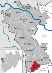
Location of Wachtendonk within Kleve district 
 | ||
| Coordinates: 51°24′33″N 6°20′16″E / 51.40917°N 6.33778°ECoordinates: 51°24′33″N 6°20′16″E / 51.40917°N 6.33778°E | ||
| Country | Germany | |
| State | North Rhine-Westphalia | |
| Admin. region | Düsseldorf | |
| District | Kleve | |
| Subdivisions | 2 | |
| Government | ||
| • Mayor | Udo Rosenkranz (CDU) | |
| Area | ||
| • Total | 48.1 km2 (18.6 sq mi) | |
| Elevation | 29 m (95 ft) | |
| Population (2012-12-31)[1] | ||
| • Total | 7,884 | |
| • Density | 160/km2 (420/sq mi) | |
| Time zone | CET/CEST (UTC+1/+2) | |
| Postal codes | 47669 | |
| Dialling codes | 0 28 36 | |
| Vehicle registration | KLE | |
| Website | www.wachtendonk.de | |
Wachtendonk at the confluence of Niers River and Nette River is a municipality in the district of Kleve in North Rhine-Westphalia, Germany. It is located west of the Rhine half way between Duisburg and Venlo at the Dutch border. Its name means 'bailiff's Donk' (Donk = slight elevation within a swampy area).
Gallery
-
Feldstrasse
-
Old Monastery 'Thal Josaphat'
-

Wankum, church (Sankt Martin Kirche) in the street
References
- ↑ "Amtliche Bevölkerungszahlen". Landesbetrieb Information und Technik NRW (in German). 31 July 2013.
External links
- Official site (German)
| Wikimedia Commons has media related to Wachtendonk. |
| |||||||
This article is issued from Wikipedia. The text is available under the Creative Commons Attribution/Share Alike; additional terms may apply for the media files.


