Vilagarcía de Arousa
| Vilagarcía de Arousa | |||
|---|---|---|---|
| Municipality | |||
| |||
| Nickname(s): Vilagarcía, Villagarcía, Villa | |||
 | |||
| Country | Spain | ||
| Autonomous Community | Galicia | ||
| Province | Pontevedra | ||
| Comarca | O Salnés | ||
| Government | |||
| • Type | Concello | ||
| • Mayor | Tomás Fole Díaz (PPdeG) | ||
| Area | |||
| • Total | 47.14 km2 (18.20 sq mi) | ||
| Population (2011)INE | |||
| • Total | 37,903 | ||
| • Density | 762.71/km2 (1,975.4/sq mi) | ||
| Demonym | Vilagarciano | ||
| Time zone | CET (GMT +1) | ||
| • Summer (DST) | CEST (GMT +2) (UTC) | ||
| Post code | 36600 | ||
| Patron saints |
Santa Rita (22nd of May) San Roque (16th of August) | ||
| Website | http://www.ivilagarcia.com/ | ||
Vilagarcía de Arousa is a spanish municipality in the province of Pontevedra, Galicia. As of 2011 it has a population of 37,903, being ninth largest town in Galicia.[1]
History
The present site of Vilagarcía has been occupied since prehistoric times. Petroglyphs depicting circular or deer shapes can be found in the parish of Bamio and can be dated to ca. 2000 B.C.E.. The castros of Alobre, Carril, Agudín and Lobeira, in addition to archaeological findings such as roman or visigothic coins, seem to indicate a continuous settlement in the area.[2]
Geography
Location
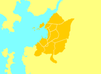
Vilagarcía de Arousa is located in the region (comarca) of O Salnés at the southernmost part of the ría de Arousa, forming a big sea inlet (ría). It borders to the North with Catoira, to the East with Caldas de Reis and to South with Vilanova de Arousa. It is located 45 km South of Santiago de Compostela.

Subdivisions
As it is traditional in Galicia, the city is subdivided in a number of parroquias, namely:[3]
- Arealonga (Santa Eulalia de Afora);
- Bamio (San Xinés);
- Carril (Santiago);
- Cea (San Pedro);
- Cornazo (San Pedro);
- Fontecarmoa (San Pedro);
- Rubiáns (Santa María);
- Sobradelo (San Salvador);
- Sobrán (San Martín de Afora);
- Solobeira (San Félix);
- Vilagarcía (Santa Eulalia e A Nosa Señora de la Junquera);
- Carril (Santiago de Afuera).
Festivals
- Festivals of Santa Rita.
- Festival of the San Roque.
- Festival of the Ameixa of Carril.
San Roque and the Festa da auga
The Patron Saint festival of Vilagarcía de Arousa take place during 10 days around the 16th of August, the day of Saint Roch (San Roque). On that day two celebrations take place consecutively. The first one, of religious nature, starts with mass and the procession of image of the saint from the parish church (Iglesia de Santa Eulalia) to St. Roch's Chapel. Thousands of people accompany the image during its way, which is carried out moving to the beat of the Triunfo paso doble. Subsequently, the second celebration takes place, what is called Festa da Auga ("the water festival"). Thousands of people from all ages go through the streets shouting for water ("¡agua!"). The neighbors respond to their prayers by throwing water from the windows with buckets, hoses, etc. The goal is to get everybody wet. In addition, the city firefighters cooperate by drenching the participants from the firetrucks. The celebration does not end until the beginning of the evening. A certain area, comprising the main streets of the city, is designated as "the wet area", where getting wet is well received. Usually between 20,000 and 30,000 people take part in the Water festival.[2]
During that week other activities take places as well: free concerts from Spanish bands, Galician folk dance and music, parades, etc. One of the most important events is the Combate Naval (naval fight), a fireworks display that gives the final touch to the festival.
Notable people
- Gustavo César, cyclist.
- Antón Paz Blanco, sailor, winner of a gold medal at the 2008 Summer Olympics in the Tornado class.
- Pepe Rubianes, actor.
- Manuel Millán, actor.
- Carlos Blanco, actor.
- Daniel Abalo Paulos, soccer player.
Twin towns
 Matosinhos, Portugal
 Gijón, Spain
References
- ↑ Institulo Nacional de Estadística
- ↑ 2.0 2.1 Turism Information of Vilagarcía de Arousa
- ↑ Nomenclátor - Instituto Nacional de Estadística
External links
Coordinates: 43°32′N 8°46′W / 43.533°N 8.767°W
| Wikimedia Commons has media related to Vilagarcía de Arousa. |

