Vermont Route 11
| ||||
|---|---|---|---|---|
 | ||||
| Route information | ||||
| Maintained by VTrans | ||||
| Length: | 42.361 mi[1] (68.173 km) | |||
| Existed: | 1922 – present | |||
| Major junctions | ||||
| West end: |
| |||
|
| ||||
| East end: |
| |||
| Location | ||||
| Counties: | Bennington, Windham, Windsor | |||
| Highway system | ||||
| ||||

Vermont Route 11 (abbreviated VT 11) is an east–west state highway in Vermont, United States. The western end of the highway is at Vermont Route 7A in Manchester. The eastern end is at the New Hampshire border at the Cheshire Bridge over the Connecticut River, connecting Springfield, Vermont and Charlestown, New Hampshire. The route continues into New Hampshire as New Hampshire Route 11, and then following that into Maine as Maine State Route 11. The three Routes 11, totaling 551.7 miles (887.9 km) in length, were once part of the New England Interstate system.
Route description
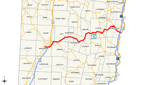
VT 11 begins as Depot Street at an intersection with VT 7A and VT 30 in Manchester Center within the Batten Kill river valley at the edge of the Green Mountains. It proceeds eastward across railroad tracks and the US 7 expressway, intersecting it at Exit 4. VT 11 and VT 30 then proceed northeast and east following along the path of Bromley Brook for another five miles (8 km) into the northern edge of the town of Winhall, where VT 30 then separates to the southeast. VT 11 continues on its eastward track, passing through the Big Bromley Ski Area and town center of Peru, on its way to the town center of Londonderry. In Londonderry center, VT 11 is known as North Main Street and has a junction and short overlap with VT 100.
VT 11 continues past Londonderry center, passing by the Magic Mountain Ski Area, towards the village of North Windham. From here, VT 11 turns northward, entering the town of Andover, following the path of the Middle Branch Williams River. VT 11 follows the river for about eight miles (13 km), as it turns eastward again in the village of Simonsville and continues towards the town center of Chester. In Chester center, VT 11 runs along Main Street, South Main Street, and Pleasant Street, overlapping with VT 103. After crossing the main Williams River, VT 11 heads east for three miles (5 km) then enters the town of Springfield. Within the urban compact of Springfield, VT 11 uses Chester Road, River Street, Main Street, and Clinton Street. VT 11 continues past the urban area following the Black River towards the Connecticut River as a 4 lane, undivided surface arterial. About a mile before reaching the Connecticut River, VT 11 is joined by U.S. Route 5 for about 0.8 miles (1.3 km), with an interchange with I-91. After US 5 separates, VT 11 continues east for another 0.2 miles (0.32 km), reverting to 2 lanes, one each way, before ending at the Cheshire Bridge at the New Hampshire state line. The road continues into New Hampshire as New Hampshire Route 11.
History
A portion of modern VT 11 in the town of Winhall was part of an early toll road known as the Peru Turnpike.
In 1922, the six New England states adopted a uniform road marking system that assigned route numbers from 1 to 99 for inter-state routes. VT 11 was originally assigned its designation as part of New England Interstate Route 11, which ran 173 miles (278 km) between New England Route 4 in Manchester, Vermont and New England Route 1 in Biddeford, Maine. Vermont formally established its state highway system in 1931, at which time the state took over maintenance of the western two-thirds of the route, between Manchester Center and Chester center, as well as the portion in Springfield along the Black River. The section from Chester center to Springfield center remained a town-maintained road until being transferred to the state in 1941.
VT 11 was extended south from Manchester Center to the New York state line west of Arlington by 1938, replacing VT 123.[2][3] The portion of VT 11 between the state line and Arlington was co-designated as VT 313 from New York to Arlington by 1940,[4] leading to the truncation of VT 11 back to Manchester Center between 1947 and 1952.[5][6]
Major intersections
| County | Location | Mile[1] | km | Destinations | Notes |
|---|---|---|---|---|---|
| Bennington | Manchester | 0.000 | 0.000 | Western terminus of VT 11 / VT 30 overlap | |
| 1.317 | 2.120 | Exit 4 (US 7) | |||
| Winhall | 6.403 | 10.305 | Eastern terminus of overlap | ||
| Windham | Londonderry | 14.755 | 23.746 | Southern terminus of overlap | |
| 15.169 | 24.412 | Northern terminus of overlap | |||
| 19.421 | 31.255 | Western terminus of VT 121 | |||
| Windsor | Chester | 29.537 | 47.535 | Northern terminus of VT 35 | |
| 29.629 | 47.683 | Western terminus of overlap | |||
| 30.016 | 48.306 | Eastern terminus of overlap | |||
| Springfield | 37.137 | 59.766 | Southern terminus of VT 106 | ||
| 37.788 | 60.814 | Western terminus of VT 143 | |||
| 41.357 | 66.558 | Western terminus of overlap | |||
| 41.542 | 66.855 | Exit 7 (I-91) | |||
| 42.161 | 67.852 | Eastern terminus of overlap | |||
| 42.361 | 68.173 | Continuation into New Hampshire | |||
| Concurrency terminus • Closed • Unopened | |||||
References
- ↑ 1.0 1.1 "2006 (Route Log) AADTs – State Highways" (PDF). Vermont Agency of Transportation. June 2007. Retrieved May 3, 2009.
- ↑ Texas Oil Company (1934). Road Map of New York (Map). Cartography by Rand McNally and Company.
- ↑ Esso (1938). New York Road Map for 1938 (Map). Cartography by General Drafting.
- ↑ Gulf Oil Company (1940). New York Info-Map (Map). Cartography by Rand McNally and Company.
- ↑ State of New York Department of Public Works. Official Highway Map of New York State (Map). Cartography by General Drafting (1947–48 ed.).
- ↑ Sunoco (1952). New York (Map). Cartography by Rand McNally and Company.