Vanvikan
| Vanvikan | |
|---|---|
| Village | |
 | |
 Vanvikan | |
| Coordinates: 63°33′09″N 10°12′35″E / 63.55250°N 10.20972°ECoordinates: 63°33′09″N 10°12′35″E / 63.55250°N 10.20972°E | |
| Country | Norway |
| Region | Trøndelag |
| County | Nord-Trøndelag |
| District | Innherred |
| Municipality | Leksvik |
| Area[1] | |
| • Total | 0.69 km2 (0.27 sq mi) |
| Elevation[2] | 59 m (194 ft) |
| Population (2009)[1] | |
| • Total | 749 |
| • Density | 1,086/km2 (2,810/sq mi) |
| Time zone | CET (UTC+01:00) |
| • Summer (DST) | CEST (UTC+02:00) |
| Post Code | 7125 Vanvikan |
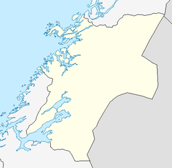
Vanvikan is a village in the municipality of Leksvik in Nord-Trøndelag county, Norway. It is located along the Trondheimsfjord in the southwestern part of the municipality. The 0.69-square-kilometre (170-acre) village has a population (2009) of 749. The population density is 1,086 inhabitants per square kilometre (2,810 /sq mi).[1] The village of Seter lies about 10 kilometres (6.2 mi) northeast of Vanvikan and the lake Storvatnet lies about 4 kilometres (2.5 mi) north of the village. One of the two schools in Leksvik municipality, Vanvikan Skole is located in Vanvikan. Stranda Church is also located in the village.
The village is an industrial centre with the various technology industries that are part of Lyng Industrier.[3] Vanvikan is connected to the city of Trondheim by means of a fast passenger boat route across the Trondheimsfjord, while the Flakk–Rørvik Ferry (car ferry) is accessed at Rørvika about 7 kilometres (4.3 mi) to the southwest. It is connected to the rest of Leksvik by Norwegian County Road 755.
References
- ↑ 1.0 1.1 1.2 Statistisk sentralbyrå (1 January 2009). "Urban settlements. Population and area, by municipality.".
- ↑ "Vanvikan" (in Norwegian). yr.no. Retrieved 2011-06-01.
- ↑ Sellæg, Arne (12 June 2005). "Lyng gir seg ikke (Lyng does not give up)". Adresseavisen.
| Wikimedia Commons has media related to Vanvikan. |