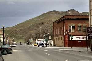
Vale, Oregon
| Vale, Oregon | |
|---|---|
| City | |
 | |
| Motto: Born and raised on the Oregon Trail | |
 | |
| Coordinates: 43°58′56″N 117°14′37″W / 43.98222°N 117.24361°WCoordinates: 43°58′56″N 117°14′37″W / 43.98222°N 117.24361°W | |
| Country | United States |
| State | Oregon |
| County | Malheur |
| Incorporated | 1889 |
| Government | |
| • Mayor | Mike McLaughlin |
| Area[1] | |
| • Total | 1.14 sq mi (2.95 km2) |
| • Land | 1.14 sq mi (2.95 km2) |
| • Water | 0 sq mi (0 km2) |
| Elevation | 2,343 ft (714 m) |
| Population (2010)[2] | |
| • Total | 1,874 |
| • Estimate (2012[3]) | 1,839 |
| • Density | 1,643.9/sq mi (634.7/km2) |
| Time zone | Mountain (UTC-7) |
| • Summer (DST) | Mountain (UTC-6) |
| ZIP code | 97918 |
| Area code(s) | 541 |
| FIPS code | 41-76600[4] |
| GNIS feature ID | 1136861[5] |
| Website | ci.vale.or.us |
Vale is a city in Malheur County, Oregon, United States, about 12 miles (19 km) west of the Idaho border. It is at the intersection of U.S. Routes 20 and 26, on the Malheur River at its confluence with Bully Creek.
Vale was selected as Malheur's county seat in 1955, 68 years after the county was founded. As of the 2010 census, the city had a total population of 1,874, down from 1,976 in 2000.[6] Vale is part of the Ontario, OR–ID Micropolitan Statistical Area.
History
The community was the first stop in Oregon along the Oregon Trail. A post office with the name of Vale was established in February 1883, and the community was incorporated by the Oregon Legislative Assembly on February 21, 1889.[7] Originally incorporated as the Town of Vale, it became the City of Vale in 1905.[7]
Geography
According to the United States Census Bureau, the city has a total area of 1.14 square miles (2.95 km2), all of it land.[1] The city has an elevation of 2,343 feet (714 m) above sea level.
Demographics
| Historical population | |||
|---|---|---|---|
| Census | Pop. | %± | |
| 1890 | 131 | ||
| 1900 | 127 | −3.1% | |
| 1910 | 992 | 681.1% | |
| 1920 | 935 | −5.7% | |
| 1930 | 922 | −1.4% | |
| 1940 | 1,083 | 17.5% | |
| 1950 | 1,518 | 40.2% | |
| 1960 | 1,491 | −1.8% | |
| 1970 | 1,448 | −2.9% | |
| 1980 | 1,558 | 7.6% | |
| 1990 | 1,491 | −4.3% | |
| 2000 | 1,976 | 32.5% | |
| 2010 | 1,874 | −5.2% | |
| source:[8] | |||
2010 census
As of the census[2] of 2010, there were 1,874 people, 669 households, and 441 families residing in the city. The population density was 1,643.9 inhabitants per square mile (634.7 /km2). There were 754 housing units at an average density of 661.4 per square mile (255.4 /km2). The racial makeup of the city was 86.7% White, 0.3% African American, 1.3% Native American, 0.4% Asian, 0.3% Pacific Islander, 8.2% from other races, and 2.8% from two or more races. Hispanic or Latino of any race were 23.4% of the population.
There were 669 households of which 38.1% had children under the age of 18 living with them, 47.8% were married couples living together, 12.0% had a female householder with no husband present, 6.1% had a male householder with no wife present, and 34.1% were non-families. 28.7% of all households were made up of individuals and 13.9% had someone living alone who was 65 years of age or older. The average household size was 2.64 and the average family size was 3.27.
The median age in the city was 33.4 years. 28.9% of residents were under the age of 18; 10.4% were between the ages of 18 and 24; 24.8% were from 25 to 44; 19.7% were from 45 to 64; and 16.4% were 65 years of age or older. The gender makeup of the city was 50.5% male and 49.5% female.
2000 census
As of the census[4] of 2000, there are 1,976 people in the city, organized into 658 households, and 488 families. The population density is 1,824.9 people per square mile (706.4/km²). There are 724 housing units at an average density of 668.7 per square mile (258.8/km²). The racial makeup of the city is 82.49% White, 1.37% Native American, 0.76% Asian, 0.15% African American, 0.10% Pacific Islander, 11.99% from other races, and 3.14% from two or more races. 24.85% of the population are Hispanic or Latino of any race.
There are 658 households out of which 40.9% have children under the age of 18 living with them, 57.0% are married couples living together, 12.8% have a female householder with no husband present, and 25.8% are non-families. 22.6% of all households are made up of individuals and 12.3% have someone living alone who is 65 years of age or older. The average household size is 2.83 and the average family size is 3.32.
The median age within the city is 32 years:
- 31.2% of the city's population is under the age of 18;
- 9.7% is from 18 to 24;
- 26.7% is from 25 to 44;
- 18.2% is from 45 to 64; and
- 14.2% are 65 years of age or older.
For every 100 females there are 99.6 males. For every 100 females age 18 and over, there are 97.1 males.
The median income for a household in the city is $27,065, and the median income for a family is $33,355. Males have a median income of $27,176 versus $22,500 for females. The per capita income for the city is $11,943. 20.0% of the population and 15.6% of families are below the poverty line. Out of the total population, 27.8% of those under the age of 18 and 12.2% of those 65 and older are living below the poverty line.
Transportation
- The Eastern Point is an intercity bus offering service between Bend and Ontario, Oregon that stops in Vale.[9]
- Miller Memorial Airpark
See also
Climate
According to the Köppen Climate Classification system, Vale has a semi-arid climate, abbreviated "BSk" on climate maps.[10]
References
- ↑ 1.0 1.1 "US Gazetteer files 2010". United States Census Bureau. Retrieved 2012-12-21.
- ↑ 2.0 2.1 "American FactFinder". United States Census Bureau. Retrieved 2012-12-21.
- ↑ "Population Estimates". United States Census Bureau. Retrieved 2013-06-02.
- ↑ 4.0 4.1 "American FactFinder". United States Census Bureau. Retrieved 2008-01-31.
- ↑ "US Board on Geographic Names". United States Geological Survey. 2007-10-25. Retrieved 2008-01-31.
- ↑ "2010 Census profiles: Oregon cities alphabetically T-Y" (PDF). Portland State University Population Research Center. Retrieved September 23, 2011.
- ↑ 7.0 7.1 Whitney, J. R. (1905). The Special Laws of the State of Oregon Enacted by The Twenty-third Legislative Assembly Regular Session. Salem, Oregon: State Printer. p. 127.
- ↑ Moffatt, Riley. Population History of Western U.S. Cities & Towns, 1850-1990. Lanham: Scarecrow, 1996, 217.
- ↑ "Eastern Point Schedule". TAC Transportation. Retrieved July 24, 2011.
- ↑ Climate Summary for Vale, Oregon
External links
| Wikimedia Commons has media related to Vale, Oregon. |
- Vale community profile from Malheur County website
- Vale Chamber of Commerce
- Vale Heritage Reflections Mural Society
- Map of Vale in PDF format
| ||||||||||||||||||||
