Urbiztondo, Pangasinan
From Wikipedia, the free encyclopedia
| Urbiztondo | ||
|---|---|---|
| Municipality | ||
 | ||
| ||
 | ||
.svg.png) Urbiztondo | ||
| Coordinates: 15°49′N 120°21′E / 15.817°N 120.350°ECoordinates: 15°49′N 120°21′E / 15.817°N 120.350°E | ||
| Country | Philippines | |
| Region | Ilocos (Region I) | |
| Province | Pangasinan | |
| District | 2nd district of Pangasinan | |
| Barangays | 21 | |
| Government[1] | ||
| • Mayor | Ernesto V. Balolong Jr. | |
| Area[2] | ||
| • Total | 81.80 km2 (31.58 sq mi) | |
| Population (2010)[3] | ||
| • Total | 47,831 | |
| • Density | 580/km2 (1,500/sq mi) | |
| Time zone | PST (UTC+8) | |
| ZIP code | 2414 | |
| Dialing code | 75 | |
| Income class | 3rd class; rural | |
Urbiztondo is a third class municipality in the province of Pangasinan, Philippines. According to the 2010 census, it has a population of 47,831 people.[3] The municipality was named after Spanish governor-general Juan Antonio de Urbiztondo y Eguía.
Barangays
Urbiztondo is politically subdivided into 21 barangays.[2]
- Angatel
- Balangay
- Batangcaoa
- Baug
- Bayaoas
- Bituag
- Camambugan
- Dalangiring
- Duplac
- Galarin
- Gueteb
- Malaca
- Malayo
- Malibong
- Pasibi East
- Pasibi West
- Pisuac
- Poblacion
- Real
- Salavante
- Sawat
Demographics
| Population census of Urbiztondo | ||
|---|---|---|
| Year | Pop. | ±% p.a. |
| 1990 | 33,102 | — |
| 1995 | 35,746 | +1.55% |
| 2000 | 40,089 | +2.32% |
| 2007 | 43,430 | +1.15% |
| 2010 | 47,831 | +3.27% |
| Source: National Statistics Office[3][4] | ||

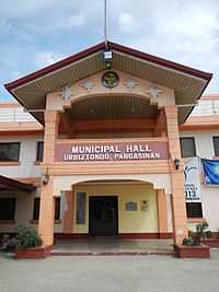
Urbiztondo Town Hall
References
- ↑ "Official City/Municipal 2013 Election Results". Intramuros, Manila, Philippines: Commission on Elections (COMELEC). 1 July 2013. Retrieved 9 September 2013.
- ↑ 2.0 2.1 "Province: PANGASINAN". PSGC Interactive. Makati City, Philippines: National Statistical Coordination Board. Retrieved 26 November 2012.
- ↑ 3.0 3.1 3.2 "Total Population by Province, City, Municipality and Barangay: as of May 1, 2010". 2010 Census of Population and Housing. National Statistics Office. Retrieved 26 November 2012.
- ↑ "Province of Pangasinan". Municipality Population Data. LWUA Research Division. Retrieved 9 September 2013.
External links
| Wikimedia Commons has media related to Urbiztondo, Pangasinan. |
- Philippine Standard Geographic Code
- Philippine Census Information
- Local Governance Performance Management System
 |
San Carlos | Basista |  | |
| Mangatarem | |
Bayambang | ||
| ||||
| | ||||
| Mangatarem |
| |||||||||||
This article is issued from Wikipedia. The text is available under the Creative Commons Attribution/Share Alike; additional terms may apply for the media files.
