Upper Wootton
From Wikipedia, the free encyclopedia
Coordinates: 51°17′18″N 1°10′09″W / 51.288265°N 1.1693°W
| Upper Wootton | |
 Upper Wootton | |
| OS grid reference | SU5802654675 |
|---|---|
| District | Basingstoke and Deane |
| Shire county | Hampshire |
| Region | South East |
| Country | England |
| Sovereign state | United Kingdom |
| Post town | TADLEY |
| Postcode district | RG26 5 |
| Dialling code | 01256 |
| Police | Hampshire |
| Fire | Hampshire |
| Ambulance | South Central |
| EU Parliament | South East England |
| UK Parliament | Basingstoke |
Upper Wootton is a small village in the civil parish of Wootton in the Basingstoke and Deane district of Hampshire, England. Its nearest town is Tadley, which lies approximately 4.8 miles (7.8 km) north-east from the village.
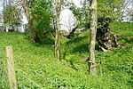
Woodgarston Motte
Half a mile north-east of the village is the overgrown ring motte known as Woodgarston Castle, a possible location for the 'Castle of the Wood' recorded as having been stormed by King Stephen in 1147.

This article is issued from Wikipedia. The text is available under the Creative Commons Attribution/Share Alike; additional terms may apply for the media files.