Untersiemau
From Wikipedia, the free encyclopedia
| Untersiemau | ||
|---|---|---|
 | ||
| ||
 Untersiemau | ||
Location of Untersiemau within Coburg district 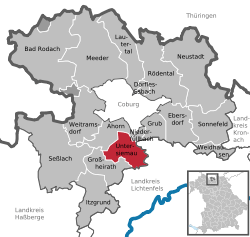 | ||
| Coordinates: 50°11′39″N 10°58′23″E / 50.19417°N 10.97306°ECoordinates: 50°11′39″N 10°58′23″E / 50.19417°N 10.97306°E | ||
| Country | Germany | |
| State | Bavaria | |
| Admin. region | Oberfranken | |
| District | Coburg | |
| Government | ||
| • Mayor | Günther Kob (SPD) | |
| Area | ||
| • Total | 20.49 km2 (7.91 sq mi) | |
| Elevation | 299 m (981 ft) | |
| Population (2012-12-31)[1] | ||
| • Total | 4,078 | |
| • Density | 200/km2 (520/sq mi) | |
| Time zone | CET/CEST (UTC+1/+2) | |
| Postal codes | 96253 | |
| Dialling codes | 09565 | |
| Vehicle registration | CO | |
| Website | www.untersiemau.de | |

Untersiemau is a municipality in the district of Coburg in Bavaria in Germany.
| |||||||
References
- ↑ "Fortschreibung des Bevölkerungsstandes". Bayerisches Landesamt für Statistik und Datenverarbeitung (in German). 31 December 2012.
This article is issued from Wikipedia. The text is available under the Creative Commons Attribution/Share Alike; additional terms may apply for the media files.