Unterperfuss
From Wikipedia, the free encyclopedia
| Unterperfuss | ||
|---|---|---|
 | ||
| ||
 Unterperfuss | ||
| Coordinates: 47°15′35″N 11°15′32″E / 47.25972°N 11.25889°ECoordinates: 47°15′35″N 11°15′32″E / 47.25972°N 11.25889°E | ||
| Country | Austria | |
| State | Tyrol | |
| District | Innsbruck Land | |
| Government | ||
| • Mayor | Leonhard Widauer | |
| Area | ||
| • Total | 2.28 km2 (0.88 sq mi) | |
| Elevation | 596 m (1,955 ft) | |
| Population (1 January 2013)[1] | ||
| • Total | 196 | |
| • Density | 86/km2 (220/sq mi) | |
| Time zone | CET (UTC+1) | |
| • Summer (DST) | CEST (UTC+2) | |
| Postal code | 6175 | |
| Area code | 05232 | |
| Vehicle registration | IL | |

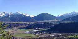
Unterperfuss is a municipality in the district of Innsbruck-Land in the Austrian state of Tyrol located 15 km west of Innsbruck and is one of the smallest villages of Tyrol. The area is restricted in the north by the Inn River and in the east by the Melach River. Unterperfuss has many facilities for the horse-riding.
Population
| Historical population | ||
|---|---|---|
| Year | Pop. | ±% |
| 1869 | 97 | — |
| 1880 | 112 | +15.5% |
| 1890 | 101 | −9.8% |
| 1900 | 110 | +8.9% |
| 1910 | 129 | +17.3% |
| 1923 | 115 | −10.9% |
| 1934 | 125 | +8.7% |
| 1939 | 120 | −4.0% |
| 1951 | 348 | +190.0% |
| 1961 | 218 | −37.4% |
| 1971 | 215 | −1.4% |
| 1981 | 201 | −6.5% |
| 1991 | 223 | +10.9% |
| 2001 | 212 | −4.9% |
| 2011 | 198 | −6.6% |
References
External links
| Wikimedia Commons has media related to Unterperfuss. |
This article is issued from Wikipedia. The text is available under the Creative Commons Attribution/Share Alike; additional terms may apply for the media files.