Ungava magmatic event
From Wikipedia, the free encyclopedia

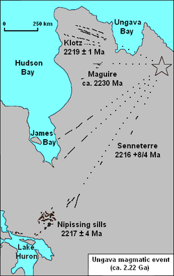
Map of features associated with the Ungava magmatic event
The Ungava magmatic event was a widespread magmatic event that began about 2.22 billion years ago during the Proterozoic Eon.
Extent
With an area of 170,000 km2 (66,000 sq mi), the Ungava magmatic event consists of a large igneous province.[1] Magmatic features that were formed during the Ungava magmatic event include the Klotz, Maguire and Senneterre dikes of Quebec and the Nipissing sills of Ontario.[2]
See also
- Volcanism of Eastern Canada
References
- ↑ 2000 Ma large mafic magmatic events
- ↑ "Regional Metallogeny Large Igneous Provinces in Canada Through Time and Their Metallogenic Potential". Mineral Deposits of Canada. Geological Survey of Canada. 2008-09-25. Retrieved 2010-05-17.
Coordinates: 57°22′52″N 68°49′34″W / 57.381°N 68.826°W
This article is issued from Wikipedia. The text is available under the Creative Commons Attribution/Share Alike; additional terms may apply for the media files.