Umhausen
| Umhausen | ||
|---|---|---|
 | ||
| ||
 Umhausen | ||
Location in the district
| ||
| Coordinates: 47°07′00″N 10°55′00″E / 47.11667°N 10.91667°ECoordinates: 47°07′00″N 10°55′00″E / 47.11667°N 10.91667°E | ||
| Country | Austria | |
| State | Tyrol | |
| District | Imst | |
| Government | ||
| • Mayor | Mag. Jakob Wolf | |
| Area | ||
| • Total | 137.4 km2 (53.1 sq mi) | |
| Elevation | 1,031 m (3,383 ft) | |
| Population (1 January 2013)[1] | ||
| • Total | 3,100 | |
| • Density | 23/km2 (58/sq mi) | |
| Time zone | CET (UTC+1) | |
| • Summer (DST) | CEST (UTC+2) | |
| Postal code | 6441 | |
| Area code | 05255 | |
| Vehicle registration | IM | |
| Website | ||


Umhausen is a municipality in the Imst district and is located 17 km southeast of Imst at the Ötztaler Ache in the Ötztal.
The municipality consists of six villages: Umhausen, Tumpen, Köfels, Farst, Niederthai, Östen.
Umhausen was once a centre for cultivation of flax.
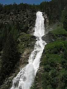
Today the main source of income is tourism. In the area of the community lies the highest waterfall of Tyrol with 150 metres. It has 2913 inhabitants.
Landslide
The Köfels landslide was a gigantic landslide, known as a sturzstrom, that occurred in the Ötz valley approximately 9800±100 years ago according to radiocarbon dating of trees buried by the event.[2] It involved a 2.5 km horizontal displacement and 800 m vertical displacement of 3.2 km3 of rock and mud along the Ötz valley floor, making it the third largest known sturzstrom.[3][4]
Population
| Historical population | ||
|---|---|---|
| Year | Pop. | ±% |
| 1869 | 1,341 | — |
| 1880 | 1,366 | +1.9% |
| 1890 | 1,186 | −13.2% |
| 1900 | 1,175 | −0.9% |
| 1910 | 1,318 | +12.2% |
| 1923 | 1,368 | +3.8% |
| 1934 | 1,485 | +8.6% |
| 1939 | 1,528 | +2.9% |
| 1951 | 1,724 | +12.8% |
| 1961 | 1,834 | +6.4% |
| 1971 | 2,050 | +11.8% |
| 1981 | 2,298 | +12.1% |
| 1991 | 2,506 | +9.1% |
| 2001 | 2,830 | +12.9% |
| 2011 | 3,078 | +8.8% |
References
- ↑ Statistik Austria - Bevölkerung zu Jahres- und Quartalsanfang, 2013-01-01.
- ↑ Ivy-Ochs S, Heuberger H, Kubik PW, Kerschner H, Bonani G, Frank M, and Schlüchter C. (1998). The age of the Köfels event — relative, 14C, and cosmogenic isotope dating of an early Holocene landslide in the central Alps (Tyrol, Austria). Zeitschrift für Gletscherkunde und Glazialgeologie, (34):57–70.
- ↑ Sørensena, SA and Bauer, B (15 August 2003). On the dynamics of the Köfels sturzstrom. Geomorphology, 54(1–2):11–19.
- ↑ Prager C, Zangerl C, Patzelt G, and Brandner R (2008). Age distribution of fossil landslides in the Tyrol (Austria) and its surrounding areas. Natural Hazards and Earth System Sciences, 8:377–407.
External links
- Information on Umhausen (German)
| Wikimedia Commons has media related to Umhausen. |
| |||||