Uberaba
| Uberaba | |||
|---|---|---|---|
 | |||
| |||
 | |||
 Uberaba | |||
| Coordinates: 19°45′S 47°56′W / 19.750°S 47.933°WCoordinates: 19°45′S 47°56′W / 19.750°S 47.933°W | |||
| Country |
| ||
| State |
| ||
| Founded by | Antônio Eustáquio da Silva e Oliveira | ||
| Government | |||
| • Mayor | Paulo Piau (2013-2016) (PMDB) | ||
| Area | |||
| • Total | 4,529.7 km2 (1,748.9 sq mi) | ||
| Elevation | 823 m (2,700 ft) | ||
| Population (2012) | |||
| • Total | 302,623 | ||
| • Density | 67/km2 (170/sq mi) | ||
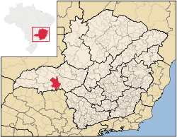
Uberaba is a city and municipality in the west of the state of Minas Gerais in Brazil. Its population is 302,623 (2012) with an area of 4529.7 km², giving a density of 60.71 people per km². It is located on a plateau at an elevation of 823 meters and is in the Uberaba River floodplain. It became a city in 1856.
Statistical micro-region
Uberaba is also a statistical micro-region including 07 municipalities: Água Comprida, Campo Florido, Conceição das Alagoas, Conquista, Delta, Uberaba, and Veríssimo. In 2007 the population was 370,645 inhabitants in a total area of 9,392.60 km². The population density was 30.62 inhab/km² (2000).[1]
History


The town was founded in 1820 by the seargeant ("sargento-mor") Antônio Eustáquio da Silva e Oliveira. The name was taken from the brazilian native language, Tupi and means "bright water". It was classified as indigenous territory on February 1811 and then as a freguesia on March 2, 1820 with the name of Santo Antônio e São Sebastião do Uberaba. Uberaba became a city on February 22, 1836.
The region known as Triângulo Mineiro, where Uberaba is located, was part of Goiás until 1816, when it became part of Minas Gerais.
The district of Peirópolis, located 19 km from the city's center, is an important Cretaceous paleontological site, first studied by the brazilian paleontologist Llewellyn Price.[2]
The city is also famous in Brazil for having been the home of Chico Xavier, a respected and popular medium.
Economy

Uberaba is the trade centre of an important agricultural area, producing cattle, soy, corn and sugarcane is now becoming an important activity as new two ethanol plants are being implanted on the city. A well-known cattle and agricultural exhibition is held there each May. In 2006 there were 133,204 head of cattle on 825 establishments, 4,216,778 head of poultry on 448 establishments and 36,230 head of swine on 303 establishments. Milk production was substantial with 29,542 liters being produced a day on 576 farms in 2006.[3]
The city's well-developed industries include cement and phosphate fertilizer plants, processed foods (sweets), cosmetics, shoe factories, furniture factories and electronics represented by a Stanley Black & Decker plant.
The city also has around twenty four chemical companies which are the largest producers of phosphated fertilizers in Latin America. Among them are Vale Fertilizantes, FMC, Sipcam Isagro Brasil, Bunge and Agronelli.
Uberaba is known nationally as a center of livestock genetic improvement and as an important producer of grain in Minas Gerais.
Freight is transported by rail and road to Belo Horizonte, the state capital 460 km to the east, and to neighbouring communities in Minas Gerais and São Paulo states.
The city is one of the largest promotional centers of cattle auctions in the country. During the expositions of zebu cattle, there are many events, which attract Brazilians and foreigners. During the year there are about 300 auctions with the sale of about 200,000 animals for reproduction, fattening, and milk.
The most famous is the Expozebu promoted by ABCZ, the greatest exposition of zebu in the world, which takes place every year in May.
Uberaba is served by Mário de Almeida Franco Airport.
Industries an Business
- Printer Magazine
- Nova América Agropecuária
- Vale Fertilizantes
- Black & Decker
- Skala
- Fertigran
- Valmont
- Mac Aluminios
Main agricultural crops in planted area (2006)
- Bananas: 28 ha.
- Coffee: 1,000 ha.
- Oranges: 1,410 ha.
- Tangerine: 168 ha.
- Cotton: 3,145 ha.
- Rice: 543 ha.
- Peanuts: 100 ha.
- Potatoes: 2,190 ha.
- Sugarcane: 36,000 ha.
- Onions: 450 ha.
- Beans: 1,450 ha.
- Manioc: 1,300 ha.
- Corn: 50,000 ha.
- Soybeans: 100,000 ha.
- Sorghum: 1,250
- Tomatoes: 240 ha.
- Wheat: 336 ha.[3]
Farm information in 2006
- Number of farms: 1,093
- Agricultural area: 282,692 ha.
- Planted area: 105,000 ha.
- Area of natural pasture: 112,678
- Workers related to producer: 1,764
- Workers not related to producer: 2,533 [3]
Higher education
Uberaba is an important university city. The nine colleges and universities offer approximately 94 courses at the undergraduate level and 49 at the graduate level. The main schools are:
- IFTM - Instituto Federal do Triângulo Mineiro
- UFTM - Universidade Federal do Triângulo Mineiro
- UNIUBE - Universidade of Uberaba
- FCETM - Faculdade de Ciências Econômicas do Triângulo Mineiro
- FAZU - Faculdades Associadas de Uberaba
- CESUBE - Centro de Ensino Superior de Uberaba
- IFET - Instituto Federal de Educação Tecnológica de Uberaba
- UNOPAR - Universidade Norte do Paraná
- UNIPAC - Universidade Presidente Antônio Carlos
- FACTHUS - Faculdade Talentos Humanos
References
- ↑ Citybrazil
- ↑ "Peirópolis - capital brasileira dos dinossauros". Archived from the original on 2007-01-27. Retrieved 2007-02-19.
- ↑ 3.0 3.1 3.2 IBGE Cidades

