Ubari
| Ubari أوباري Awbari | |
|---|---|
| Town | |
 | |
 Ubari | |
| Coordinates: 26°35′N 12°46′E / 26.583°N 12.767°E | |
| Country |
|
| Region | Fezzan |
| District | Wadi al Hayaa |
| Elevation[1] | 1,535 ft (468 m) |
| Population (2009) | |
| • Total | 35,000 |
| Time zone | UTC + 2 |
Ubari or Awbari (Arabic: أوباري) is an Berber-speaking oasis town and the capital of the Wadi al Hayaa District, in the Fezzan region of southwestern Libya. It is in the Libyan section of the Sahara Desert. It was the capital of the former Baladiyah (district) called Awbari, in the southwest of the country.
Geography
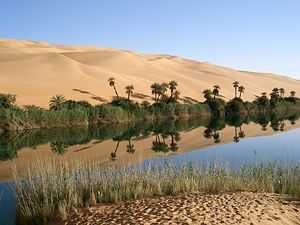
Ubari is in the Targa valley, lying between the Messak Sattafat plateau and Idhan Ubari erg sand dunes and lakes. Native plants include wetland grasses at the natural spring fed lakes' shorelines, and the native Saharan Date palm (Phoenix dactylifera)
The Ubari oasis settlement is the second center for the Kel Ajjer Tuareg people, after Ghat. Neighbouring villages include Germa, and Garran.
2011 Libyan civil war
During the 2011 Libyan civil war the town was captured by the forces of the National Transitional Council on 22 September 2011.[2]
On 19 November 2011, Saif al-Islam Gaddafi and a few associates were captured and detained about 50 kilometers west of Ubari as they were trying to flee to neighbouring Niger.[3]
See also
References
- ↑ Wolfram Alpha
- ↑ Fahim, Kareem; Gladstone, Rick. "NATO Extends Libya Bombing Campaign". New York Times. Retrieved 22 September 2011.
- ↑ "Gaddafi's son Saif al-Islam captured in Libya". BBC. 19 November 2011. Retrieved 19 November 2011.
External links
| Wikimedia Commons has media related to Ubari oasis. |
| |||||
Coordinates: 26°35′N 12°46′E / 26.583°N 12.767°E