Twin Mound, Kansas
| Twin Mound, Kansas | |
|---|---|
| Ghost town | |
 | |
 Twin Mound, Kansas | |
| Coordinates: 38°51′37″N 95°28′54″W / 38.86028°N 95.48167°WCoordinates: 38°51′37″N 95°28′54″W / 38.86028°N 95.48167°W | |
| Country | United States |
| State | Kansas |
| County | Douglas |
| Elevation | 1,056 ft (322 m) |
| Time zone | Central (CST) (UTC-6) |
| • Summer (DST) | CDT (UTC-5) |
| Area code(s) | 785 |
| GNIS feature ID | 482172[1] |
Twin Mound was a townsite in western Douglas County, Kansas, United States. It was named for two natural mounds that rise gently from the landscape.
History
Henry Hiatt was born in Dublin, Indiana in 1816. In 1856, Hiatt, his wife and five children moved to Kansas Territory settling in Bloomington. Shortly after his arrival, Hiatt and two other men operated a saw mill but within a year Hiatt decided to move on and transported his family seven miles southwest. The two nearly identical mounds inspired Hiatt for he settled in the area and founded his own community, Twin Mounds.
Hiatt gave no explanation as to why he left Bloomington but Hiatt resented the power of organized church in American society, preferred Confucious's version of the Golden Rule and possibly objected to the regulations the Bloomington Town Company was imposing on the residents. Hiatt was, to a large degree, an anarchist. Hiatt died in 1900 and was buried in a homemade coffin in Twin Mound Cemetery, a cemetery he started in 1858 when his first wife died.

Eventually the s was dropped from the town name. The small farming community was growing steadily and Hiatt had big plans for the town. He began talking up the Twin Mounds Harmonic College which would teach science, facts and laws; not sect, doctrine, nature or creed. The college would also be open to all races, creeds and sexes. Why Hiatt failed in this venture is possibly due to Hiatt's lack of experience and going up against stronger opposition who wanted a university in Lawrence.
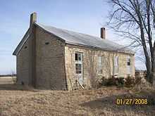
The townsite remains a small farming community. All that remains is the one-room schoolhouse, the cemetery and the two mounds.
References
- ↑ "US Board on Geographic Names". United States Geological Survey. 2007-10-25. Retrieved 2008-01-31.
| ||||||||||||||||||||
