Turkish Straits

The term Turkish Straits (Turkish: Türk Boğazları) refers to the two narrow straits in northwestern Turkey, the Bosphorus and the Dardanelles, that connect the Sea of Marmara with the Black Sea on one side and the Aegean arm of the Mediterranean Sea on the other. They are conventionally considered the boundary between the continents of Europe and Asia. The Turkish Straits have been governed since 1936 by the Montreux Convention.
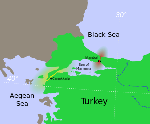
- The Bosphorus (also spelled Bosporus; Turkish: Boğaziçi or İstanbul Boğazı, "Istanbul Strait"), about 30 kilometers (19 mi) long and only 700 meters (2,300 ft) wide, connects the Sea of Marmara with the Black Sea in the north. It runs through the city of Istanbul, making it a city located on two continents. It is crossed by two suspension bridges (the Bosphorus Bridge and the Fatih Sultan Mehmet Bridge) and the Marmaray rail tunnel.
- The Dardanelles (historically also Hellespont; Turkish: Çanakkale Boğazı, "Çanakkale Strait"), 68 km (42 mi) long and 1.2 km (0.75 mi) wide, connects the Sea of Marmara with the Mediterranean in the southwest, near the city of Çanakkale. In classical antiquity the Dardanelles strait was known as the Hellespont. The strait and the Gallipoli (Gelibolu) peninsula on its western shoreline were the scene of the Battle of Gallipoli during the First World War.
The Straits Question
The Straits have been of urgent maritime strategic importance since the Trojan War was fought near the Aegean entrance. In the declining days of the Ottoman Empire the "Straits Question" involved the diplomats of Europe and the Ottoman Empire.
By the terms of the London Straits Convention concluded on July 13, 1841, between the Great Powers of Europe — Russia, the United Kingdom, France, Austria and Prussia — the "ancient rule" of the Ottoman Empire was re-established by closing the Turkish straits to all warships whatsoever, barring those of the sultan's allies during wartime. It thus benefited British naval power at the expense of Russian as the latter lacked direct access for its navy to the Mediterranean.[1]
The treaty is one in a series dealing with access to the Bosphorus, the Sea of Marmara, and the Dardanelles. It evolved from the secret 1833 Treaty of Hünkâr İskelesi (Unkiar Skelessi), in which the Ottoman Empire guaranteed exclusive use of the Straits to "Black Sea Powers" (i.e., Ottoman Empire and Russian Empire) warships in the case of a general war.
The modern treaty controlling relations is the 1936 Montreux Convention Regarding the Regime of the Turkish Straits, which is still in force. It gives Republic of Turkey control over warships entering the straits but guarantees the free passage of civilian vessels in peacetime.
See also
- List of maritime incidents in the Turkish Straits
- United Nations Convention on the Law of the Sea
- Marmara Region
- International law
- Hellespont
References
- ↑ Christos L. Rozakis (1987). The Turkish Straits. Martinus Nijhoff Publishers. pp. 24–25.
Coordinates: 40°43′21″N 28°13′29″E / 40.7225°N 28.2247°E