Tule Lake
| Tule Lake | |
|---|---|
 Overview of the Tule Lake Basin | |
| Location | Siskiyou / Modoc counties, California, USA |
| Coordinates | 41°54′33.56″N 121°31′58.97″W / 41.9093222°N 121.5330472°WCoordinates: 41°54′33.56″N 121°31′58.97″W / 41.9093222°N 121.5330472°W |
| Type | intermittent lake |
| Primary inflows | Lost River |
| Basin countries | United States |
| Max. length | 8.0 km (5.0 mi) |
| Max. width | 4.8 km (3.0 mi) |
| Surface area | 13,000 acres (5,300 ha) |
| Surface elevation | 4,035 ft (1,230 m) |
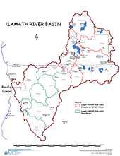
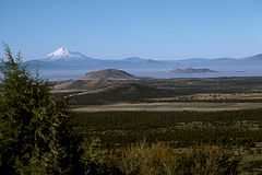
Tule Lake is an intermittent lake covering an area of 13,000 acres (53 km2), 8.0 km (5.0 mi) long and 4.8 km (3.0 mi) across,[1] in northeastern Siskiyou County and northwestern Modoc County in California, along the border with Oregon.
Geography
Tule Lake is fed by the Lost River. The elevation of the lake is 4,035 ft (1,230 m).[1]
Tule Lake is located 2.4 km (1.5 mi),[1] southwest of the town of Tulelake in Northern California.
Wildlife and water
It is part of the Tule Lake National Wildlife Refuge and the Klamath Project.
History
Canby's Cross is located about three miles south of the lake; it is the site where General Edward Canby was killed by the Modoc chief Kintpuash, also known to American settlers as Captain Jack.
During World War II, the United States government forced the evacuation of Japanese nationals and Japanese Americans, including citizens born in the United States, to numerous camps built in the interior of California and inland states. They were forced to sell their businesses and homes, and suffered enormous economic and psychological losses by being treated as potential enemies. The Tule Lake War Relocation Center, a Japanese American internment camp, is located to the east in neighboring Modoc County.
See also
References
| |||||||||||||||||||||||||