Tulbagh
| Tulbagh | |
|---|---|
 | |
 Tulbagh | |
| Coordinates: 33°17′6″S 19°8′16″E / 33.28500°S 19.13778°ECoordinates: 33°17′6″S 19°8′16″E / 33.28500°S 19.13778°E | |
| Country | South Africa |
| Province | Western Cape |
| District | Cape Winelands |
| Municipality | Witzenberg |
| Established | 1795[1] |
| Area[2] | |
| • Total | 3.81 km2 (1.47 sq mi) |
| Population (2011)[2] | |
| • Total | 8,969 |
| • Density | 2,400/km2 (6,100/sq mi) |
| Racial makeup (2011)[2] | |
| • Black African | 22.7% |
| • Coloured | 69.3% |
| • Indian/Asian | 0.2% |
| • White | 6.9% |
| • Other | 0.8% |
| First languages (2011)[2] | |
| • Afrikaans | 74.4% |
| • Xhosa | 18.3% |
| • English | 3.6% |
| • Sotho | 2.0% |
| • Other | 1.7% |
| Postal code (street) | 6820 |
| PO box | 6820 |
| Area code | 023 |
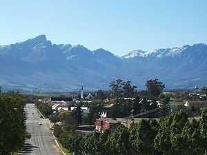
Tulbagh, named after Cape governor Ryk Tulbagh, is a town located in a mountain basin, the "Land van Waveren" (i.e. Land of Waveren or Tulbagh basin),[3] in the western Witzenberg Local Municipality of the Winelands of the Western Cape, South Africa. The basin is fringed on three sides by mountains, and is drained by the Klein Berg river and its tributaries. The nearest towns are Ons Rust and Gouda beyond the Nuwekloof Pass, Wolseley some 15 kilometres (9.3 mi) to the south inside the basin, and Ceres and Prince Alfred Hamlet beyond Michell's Pass in the Warm Bokkeveld.
History
The basin has been inhabited for thousands of years by indigenous Bushmen and Khoi peoples. It was about 300 years ago when, after a land grant by the Dutch Colonial Government to a more or less equal number of Dutch and Huguenot settlers to settle the area, that the town of Tulbagh was founded. The town developed slowly and over time and in the period many notable examples of Cape Dutch architecture, Victorian and Edwardian houses and other buildings such as the Oude Kerk (1743) and the Oude Drosdy (the original colonial Magistrate's complex) were built. Many of these lovely buildings were destroyed in an earthquake in 1969 but quite a number survived the catastrophe. Church Street in Tulbagh is now graced by possibly the largest number of Cape-Dutch, Edwardian and Victorian provincial heritage sites in one street in South Africa and remains a major tourist attraction of the town to the present day.
Geography
The bowl is surrounded by imposing mountain ranges, the Obiqua Mountains to the west, Winterhoek Mountain to the north and the Witsenberg range to the east, with peaks that rise to over 1,500 metres (4,900 ft). The basin experiences a mediterranean-type climate. The southern side is open to cooling south-east winds during the hot summer months. Accordingly Tulbagh enjoys some of the most diverse and attractive conditions for viticulture in the Cape, and the differences in terroir available to wine makers allow for a wide diversity of distinctive wines of excellence, attributes which have attracted many new producers to the valley.
Wine production

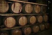
Wine has been produced for many years in the basin on a commercial scale, but only recently have large advances been made. There are now numerous and some world famous wine estates producing award winning wines.
The importance of this industry for the vicinity is unquestionably substantial, so much so that many of the producers are now part of the Tulbagh Wine Route and this is attracting increasing numbers of tourists to Tulbagh who are eager to sample the wines produced by the members.
Many new vineyards have been planted and more private cellars are either being planned or built to cope with the expected production volumes of quality wines.
See also
References
- ↑ "Chronological order of town establishment in South Africa based on Floyd (1960:20-26)". pp. xlv–lii.
- ↑ 2.0 2.1 2.2 2.3 "Main Place Tulbagh". Census 2011.
- ↑ James, Wilmot G. and Mary Simons (ed.) (9 January 2009). Class, Caste and Color: A Social and Economic History of the South African Western Cape. Transaction Publishers. p. 2. ISBN 1412808650.
External links
| Wikimedia Commons has media related to Tulbagh. |
- Tulbagh Information - a wealth of information
| |||||||||||||||||||||||

.svg.png)