Tsovinar, Armenia
Coordinates: 40°09′39″N 45°27′14″E / 40.16083°N 45.45389°E
| Tsovinar Ծովինար | |
|---|---|
 | |
 Tsovinar Ծովինար | |
| Coordinates: 40°09′39″N 45°27′14″E / 40.16083°N 45.45389°E | |
| Country | Armenia |
| Marz (Province) | Gegharkunik |
| Government | |
| • Mayor | Mher Martoyan |
| Population (2008) | |
| • Total | 4,310 |
| Time zone | (UTC+4) |
| • Summer (DST) | (UTC+5) |
Tsovinar (Armenian: Ծովինար; formerly, Kolakran) is a village in the Gegharkunik Province of Armenia. The name roughly translates to "beach beside the sea". East of the village is the Urartian city of Teyseba (Odzaberd) founded by Rusa I, with a cuneiform inscription nearby. It is considered to be the best preserved Urartian site in the Sevan basin. Just outside of the village headed southeast are numerous stones scattered across the side of a hill. It is all that remains of an ancient village destroyed during a war long ago. Some human bones and old coins have been found in this area by villagers from Tsovinar, attesting to the story of what had happened here. Not too far away are also two small single-nave churches. The church of Topi Galugh sits on a hill southeast between Tsovinar and Artsvanist, while the church of Surb Sarkis built between 1100-1200 sits south of the village of Tsovinar on a promontory overlooking a small gorge. Next to Surb Sarkis is a small cemetery, and just below the church in the gorge is a small spring and cave. Further south are the remains of the ancient village of Karmrashen, which contains the church of Hnevank, the monument of Yot Verk Matur, numerous khachkars, and some tombs.
Gallery
-

Overlooking Teyseba and Lake Sevan. Tsovinar is located in the distance to the left.
-
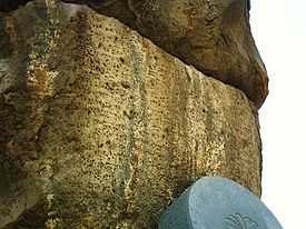
Cuneiform inscription of Rusa I at the base of the hill of Teyseba, near the road leading towards Artsvanist.
References
- '32FA881E68EA3774E0440003BA962ED3'&Diacritics=DC Tsovinar, Armenia at GEOnet Names Server
- World Gazeteer: Armenia – World-Gazetteer.com
- Report of the results of the 2001 Armenian Census, National Statistical Service of the Republic of Armenia
- Kiesling, Brady (2005), Rediscovering Armenia: Guide, Yerevan, Armenia: Matit Graphic Design Studio
- Brady Kiesling, Rediscovering Armenia, p. 46; original archived at Archive.org, and current version online on Armeniapedia.org.
