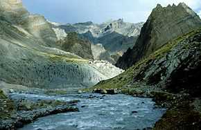
The Tsarap River or the Tsarap Chu (Urdu: صراف ندی), is a river 182 kilometres (113 mi) long, which forms the eastern part of the Zanskar valley, in the Ladakh region of the Indian state of Jammu and Kashmir.
Geography
The Tsarap River has its source in the glaciers near Pankpo La Pass at the border of Jammu and Kashmir and Himachal Pradesh.[1] After rising from its source, the Tsarap River flows southwest up to Sarchu, a camping site at the Leh-Manali Highway, here the Tsarap River joins a confluent of three rivers of Lingti, Yunan and Sarchu River.[2] At village Purne, the Tsarap River is joined by Kargyag River which originates near Shingo La pass.[3] Then the Tsarap River flows down in the main Zanskar valley, through the towns of Mone, Tichip, Jamyang Lang, Dorzong and Chia. The river then passes a confluence with its tributary, the Stod River, at Padum, the capital of Zanskar. Together, these two rivers form the Zanskar River, a tributary of the Indus River.[4]
The Tsarap River contributes to the minimal agricultural production of the Zanskar valley, mainly to the lower areas of Chia, by providing irrigation to the fields of barley, wheat, buckwheat and peas.[5] Accessible in the summer, the Pensi La mountain pass which connects Zanskar with rest of the country, receives heavy snowfall along with the other pass Zojila, which results in the valley is cut off during winter from rest of the state, and the river freezes during this season. The river source at Pankpo La near Sarchu lies 255 kilometres (158 mi) southeast from the nearest airport of Leh. The Tsarap River is famous for adventure sports. Rafting events are organised in the Tsarap, Stod and the Zanskar rivers.[6][7]
Gallery
References
|
|---|
| | Passes | |
|---|
| | Valleys | |
|---|
| | Cities and Towns | |
|---|
| | Rivers, glaciers and lakes | |
|---|
| | Monasteries | |
|---|
| | See also | |
|---|
|
|
|---|
| | Rivers | |
|---|
| | Lakes | |
|---|
| | Glaciers | |
|---|
| | Dams, Barrages | |
|---|
| | Hydrography of surrounding areas |
- Himachal Pradesh
- Punjab, India
- Pakistan
|
|---|
|

