Troubridge Island
 | |
| Geography | |
|---|---|
| Location | Gulf St Vincent |
| Country | |
|
Australia | |
 | |
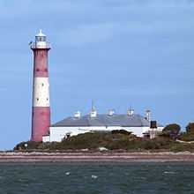
| Troubridge Island Lighthouse | |
| Location | Troubridge Island, South Australia |
|---|---|
| Year first lit | 1856. |
| Deactivated | 2001 |
| Construction | cast iron |
| Tower shape | round tower |
| Markings / pattern | painted with broad red and white horizontal bands |
| Height | 24 metres (79 ft) |
| Admiralty number | K2022 |
| ARLHS number | AUS-164 |

Troubridge Island is a small sandy island lying about 7 km east of Sultana Point on the Yorke Peninsula at the south-western end of Gulf St Vincent, South Australia. It is important as a seabird colony site.
Description
Troubridge is a low island with a maximum height of about 5 m above sea level. Its land area is only about 3 ha at high tide but expands to about 8 ha of exposed sand flats at low tide. Apart from a disused lighthouse with two associated cottages used for tourist accommodation, the island is designated as a conservation park known as the Troubridge Island Conservation Park. Access is only by permit or with an approved commercial tour operator.[2][3]
Plants
Most of the 31 plant species recorded from the island are introduced. The vegetation consists of low shrubland dominated by Nitre Bush, Grey Saltbush and African Boxthorn. Other prominent plants present are Tree Mallow, Sea Rocket, Marram Grass and Hairy Spinifex.[2]
Birds
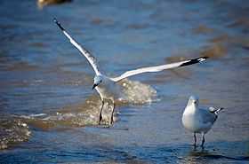
The island has been identified as an Important Bird Area (IBA) by BirdLife International because it supports over 1% of the world populations of Black-faced Cormorants (with up to 4000 individuals) and Silver Gulls (with up to 10,000 breeding pairs.[4] It also supports breeding colonies of Little Penguins, Caspian, Crested and Fairy Terns, Pied Cormorants and, sometimes, small numbers of Pacific Gulls. It provides foraging habitat for Red-necked Stints. Rock Parrots have been recorded.[2]
Troubridge Shoals
Troubridge Island is part of Troubridge Shoals which extend across to Yorke Peninsula and constitutes a hazard to shipping. Troubridge Shoals has been the cause of over 33 wrecks and groundings. In 1850, at least seven vessels ran aground, precipitating the erection of a lighthouse in 1855.[5]
External links
References
- ↑ "Cape Jervis (2)". Russ Rowlett and the University of North Carolina at Chapel Hill. Retrieved 31 December 2013.
- ↑ 2.0 2.1 2.2 BirdLife International. (2011). Important Bird Areas factsheet: Troubridge Island. Downloaded from http://www.birdlife.org on 2011-11-16.
- ↑ "Troubridge Island". Department of Environment, Water and Natural Resources. Retrieved 14 March 2013.
- ↑ "IBA: Troubridge Island". Birdata. Birds Australia. Retrieved 2011-11-14.
- ↑ Noble, John Hazards of the Sea, Angus and Robertson, 1970 ISBN 0-207-12070-6
| ||||||||||||||
| |||||||||||||||||||||||
Coordinates: 35°07′23″S 137°49′38″E / 35.12306°S 137.82722°E