Tropolje
| Tropolje (Završje) | |
|---|---|
| Historical regiona | |
| |
| Country |
|
| Largest city | Livno |
| Areab | |
| • Total | 4,343 km2 (1,677 sq mi) |
| Population (2013)b | |
| • Total | 83,541 |
| • Density | 19.24/km2 (49.8/sq mi) |
| Time zone | CET (UTC+1) |
| • Summer (DST) | CEST (UTC+2) |
|
a Tropolje is not an official subdivision of the Bosnia and Herzegovina, it is a historical region. b The figure is an approximation based on the territorial span and population of five municipalities in Herzeg-Bosnia County (Bosansko Grahovo, Glamoč, Kupres, Livno, and Tomislavgrad). | |
Tropolje is a historical region[1] of Bosnia and Herzegovina that encompasses territory around karst fields of Livno, Tomislavgrad and Glamoč. The wider zone of this region also comprises the fields of Kupres and Bosansko Grahovo. Name that encompasses all of these fields is Završje or Western Regions (Croatian: Zapadne strane). The region has no official definition, and its borders and extent are described differently by various sources.
Municipalities
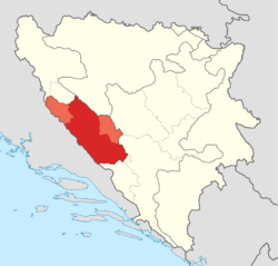
Area of Završje covers territory of five municipalities in the Federation of Bosnia and Herzegovina: Grahovo, Glamoč, Kupres, Livno and Tomislavgrad. Some parts of municipalities Drvar and Šipovo are also included in this region.
| Municipality | Coat of arms | Population[2] | Area (km2)[3] |
|---|---|---|---|
| Bosansko Grahovo | | 3,091 | 780.0 |
| Glamoč | | 4,038 | 1033.6 |
| Kupres | | 5,893 | 569.8 |
| Livno | | 37,487 | 994.0 |
| Tomislavgrad | | 33,032 | 967.4 |
Geography
Završje is located between Dalmatia to the west, Bosanska Krajina to the north, Central Bosnia to the east and Herzegovina to the south and southeast. Završje covers 4,343 square kilometres (1,677 square miles), and has population of 68,809—making the region the most sparsely populated region of Bosnia and Herzegovina at 15.84/km2 (41.0/sq mi).
Topography
Mountainous terrain of the region is a part of the Dinaric Alps, linked to a Late Jurassic to recent times fold and thrust belt, itself part of the Alpine orogeny, extending southeast from the southern Alps.

| Highest mountains of Tropolje | |||
|---|---|---|---|
| Mountain | Peak | Elevation | Coordinates |
| Vran | Veliki Vran | 2,074 m (6,804 ft) | 43°40′4.8″N 17°30′18″E / 43.668000°N 17.50500°E |
| Vran | Mali Vis | 2,014 m (6,608 ft) | 43°40′41.34″N 17°29′57.08″E / 43.6781500°N 17.4991889°E |
| Cincar | Cincar | 2,006 m (6,581 ft) | 43°54′08″N 17°03′46″E / 43.90222°N 17.06278°E |
| Vran | Crno Brdo | 1,966 m (6,450 ft) | 43°40′52.96″N 17°29′37.3″E / 43.6813778°N 17.493694°E |
| Vran | Mali Vran | 1,961 m (6,434 ft) | 43°39′8.8″N 17°17′27″E / 43.652444°N 17.29083°E |
| Vran | Bijela Glava | 1,949 m (6,394 ft) | 43°39′34″N 17°29′56″E / 43.65944°N 17.49889°E |
| Vitorog | Veliki Vitorog | 1,907 m (6,257 ft) | 44°7′12″N 17°2′45″E / 44.12000°N 17.04583°E |
| Golija | Veliki Vrh | 1,886 m (6,188 ft) | 43°59′12″N 16°47′21″E / 43.98667°N 16.78917°E |
| Vran | Priorac | 1,881 m (6,171 ft) | 43°39′37″N 17°28′27″E / 43.66028°N 17.47417°E |
| Šator | Veliki Šator | 1,872 m (6,142 ft) | 44°9′26″N 13°35′23″E / 44.15722°N 13.58972°E |
Hydrology and climate
The entire Tropolje region is encompassed by the Adriatic Sea drainage basin except small part of the northern field of Glamoč which is encompassed by the Black Sea drainage basin. Tropolje contains several losing streams such as Bistrica, Sturba, Šujica, Žabljak, Vrba, reflecting a high degree of karstification of the terrain in the region, resulting in increased permeability of soil and rocks. Ingress of water underground resulted in formation of subterranean watercourses and lakes.
History

Tropolje has been inhabited at least since Neolithic times. In the late Bronze Age, the Neolithic population was replaced by more warlike Indo-European tribes known as the Illyrians. The region was inhabited by Illyrian tribe of Dalmatae. Their capital was Delminium which was located in today's Tomislavgrad. The Dalmatae left many remains that testify about their presence in this area. The most important remains are the gradine, remains of Illyrian settlements which were distributed along the karst fields. The settlements were strategically well placed, that is why the Romans took over 200 years to occupy this region.
References
- ↑ http://chapters.scarecrowpress.com/08/108/0810850842ch1.pdf
- ↑ (Croatian)"Rezultati popisa 2013. (Census 2013 Results)". http://www.bhas.ba/. Agency for Statistics of Bosnia and Herzegovina. Retrieved 7 November 2013.
- ↑ (Bosnian)(Croatian) "Kanton 10 u brojkama (Canton 10 in numbers)". The Federal Office of Statistics of Federation of Bosnia and Herzegovina. Retrieved 28 May 2013.
Coordinates: 43°49′25″N 17°00′15″E / 43.82361°N 17.00417°E