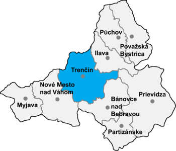
Trenčín District
From Wikipedia, the free encyclopedia
| Trenčín District | |
|---|---|
| District | |
 | |
| Country | Slovakia |
| Region (kraj) | Trenčín Region |
| Area | |
| • Total | 672 km2 (259 sq mi) |
| Population (2001) | |
| • Total | 112,767 |
| • Density | 170/km2 (430/sq mi) |
| Time zone | CET (UTC+1) |
| • Summer (DST) | CEST (UTC+2) |
Trenčín District (Slovak: okres Trenčín, Hungarian: Trencséni járás) is a district in the Trenčín Region of western Slovakia. Until 1918, the district was part of the county of Kingdom of Hungary of Trencsén.
Municipalities
- Adamovské Kochanovce
- Bobot
- Dolná Poruba
- Dolná Súča
- Drietoma
- Dubodiel
- Horná Súča
- Horňany
- Horné Srnie
- Hrabovka
- Chocholná-Velčice
- Ivanovce
- Kostolná-Záriečie
- Krivosúd-Bodovka
- Melčice-Lieskové
- Mníchova Lehota
- Motešice
- Nemšová
- Neporadza
- Omšenie
- Opatovce
- Petrova Lehota
- Selec
- Skalka nad Váhom
- Soblahov
- Svinná
- Štvrtok
- Trenčianska Teplá
- Trenčianska Turná
- Trenčianske Jastrabie
- Trenčianske Mitice
- Trenčianske Stankovce
- Trenčianske Teplice
- Trenčín
- Veľká Hradná
- Veľké Bierovce
- Zamarovce
| |||||||
Coordinates: 48°54′N 18°02′E / 48.900°N 18.033°E
This article is issued from Wikipedia. The text is available under the Creative Commons Attribution/Share Alike; additional terms may apply for the media files.