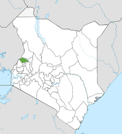
Trans-Nzoia County
From Wikipedia, the free encyclopedia
| Trans-Nzoia County | |
|---|---|
| County | |
 | |
| Country |
|
| Formed | March 4th 2013 |
| Capital | Kitale |
| Government | |
| • Governor | Patrick Simiyu |
| Area | |
| • Total | 2,469.9 km2 (953.6 sq mi) |
| Population (2009) | |
| • Total | 818,757 [1] |
| Time zone | EAT (UTC+3) |
Trans-Nzoia County is a county in the former Rift Valley Province, Kenya, located between the Nzoia River and Mount Elgon with its centre at the town of Kitale which is the capital and largest town of the county.
Historically the area has been inhabited by the Kalenjin and Bukusu people. After independence many of the farms vacated by white settlers were bought by individuals from other ethnic groups in Kenya.
The county is largely Agricultural with both large scale and small scale wheat, maize and dairy farming. The county is fondly referred to as the basket of Kenya for its role in food production in the country.
The district has three constituencies:
- Cherangani Constituency
- Kwanza Constituency
- Saboti Constituency
| Local authorities (councils) | |||
| Authority | Type | Population* | Urban pop.* |
|---|---|---|---|
| Kitale | Municipality | 86,055 | 63,245 |
| Nzoia | County | 489,607 | 0 |
| Total | - | 575,662 | 63,245 |
| * 1999 census. Source: | |||
| Administrative divisions | |||
| Division | Population* | Urban pop.* | Headquarters |
|---|---|---|---|
| Central | 147,992 | 42,884 | Kitale |
| Cherangany | 52,974 | 0 | Cherangani |
| Endebess | 61,481 | 0 | Endebess |
| Kaplamai | 89,858 | 0 | |
| Kiminini | 64,685 | 0 | Kiminini |
| Kwanza | 88,727 | 0 | Kwanza |
| Saboti | 69,945 | 0 | Saboti |
| Total | 575,662 | 42,884 | - |
| * 1999 census. Sources: , , | |||
See also
- Mombasa County
- Kwale County
- Kilifi County
- Tana River County
- Lamu County
- Taita Taveta County
- Garissa County
- Wajir County
- Mandera County
- Marsabit County
- Isiolo County
- Meru County
- Tharaka Nithi County
- Embu County
- Kitui County
- Machakos County
- Makueni County
- Nyandarua County
- Nyeri County
- Kirinyaga County
- Muranga County
- Kiambu County
- Turkana County
- West Pokot County
- Samburu County
- Trans-Nzoia County
- Uasin Gishu County
- Elgeyo Marakwet County
- Nandi County
- Baringo County
- Laikipia County
- Nakuru County
- Narok County
- Kajiado County
- Kericho County
- Bomet County
- Kakamega County
- Vihiga County
- Bungoma County
- Busia County
- Siaya County
- Kisumu County
- Homa Bay County
- Migori County
- Kisii County
- Nyamira County
- Nairobi County
References
Coordinates: 1°06′N 34°57′E / 1.1°N 34.95°E
This article is issued from Wikipedia. The text is available under the Creative Commons Attribution/Share Alike; additional terms may apply for the media files.