Tranøy
| Tranøy kommune Ránáidsullo suohkan | |||
|---|---|---|---|
| Municipality | |||
| |||
 | |||
| Coordinates: 69°11′29″N 17°21′44″E / 69.19139°N 17.36222°ECoordinates: 69°11′29″N 17°21′44″E / 69.19139°N 17.36222°E | |||
| Country | Norway | ||
| County | Troms | ||
| District | Midt-Troms | ||
| Administrative centre | Vangsvik | ||
| Government | |||
| • Mayor (2003) | Odd Arne Andreassen (Ap) | ||
| Area | |||
| • Total | 523.79 km2 (202.24 sq mi) | ||
| • Land | 499.17 km2 (192.73 sq mi) | ||
| • Water | 24.62 km2 (9.51 sq mi) | ||
| Area rank | 201 in Norway | ||
| Population (2012) | |||
| • Total | 1,524 | ||
| • Rank | 358 in Norway | ||
| • Density | 3.1/km2 (8/sq mi) | ||
| • Change (10 years) | -9.5 % | ||
| Demonym | Tranøyværing[1] | ||
| Time zone | CET (UTC+1) | ||
| • Summer (DST) | CEST (UTC+2) | ||
| ISO 3166 code | NO-1927 | ||
| Official language form | Neutral | ||
| Website | www.tranoy.kommune.no | ||
|
| |||
Tranøy is a municipality in Troms county, Norway. The municipality is situated on the southern coast of the large island of Senja. The administrative centre is the village of Vangsvik in the eastern part of the municipality. Other important villages include Stonglandseidet, Skrollsvika, and Å.
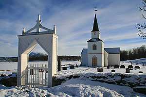
The now abandoned island of Tranøya, with the 18th-century wooden Tranøy Church, used to be the centre of activities for the municipality. From Tranøybotn it is only a short walk to the Ånderdalen National Park, with varied landscapes within a very limited area, including deep pine forests.
General information

The large municipality of Tranøy was established on 1 January 1838 (see formannskapsdistrikt). The original municipality included all the land surrounding the large Solbergfjorden. On 1 September 1886, the municipality was divided into three separate municipalities: Tranøy, Dyrøy, and Sørreisa. After this, Tranøy had 1,239 inhabitants.
On 1 January 1964 several changes took place. The mainland areas of Tranøy (population: 382) were transferred to Dyrøy and the Hellemo, Paulsrud, Johnsgård, and Stormo farms (population: 106) were transferred to Lenvik. At the same time, the parts of Bjarkøy on Senja and Lemmingsvær islands (population: 480) and the Rødsand area of Torsken (population: 160) were both transferred to Tranøy.[2]
Name
The municipality (originally the parish) is named after the small island of Tranøya (Old Norse: Tranøiar), since the first church (Tranøy Church) was built there. The first element is comes from trana which means "crane" and the last element is øy which means "island". Prior to 1909, the name was written Tranø.[3]
Coat-of-arms
The coat-of-arms is from modern times. They were granted on 15 May 1987. The arms show an Atlantic halibut (Hippoglossus hippoglossus), a main species of local fish, which symbolizes the importance of fishing for the local community. In addition to this, the fish played a major role in local legends, similar to the role of bears in land-based legends.[4]
Churches

The Church of Norway has one parish (sokn) within the municipality of Tranøy. It is part of the Senja deanery in the Diocese of Nord-Hålogaland.
| Parish (Sokn) | Church Name | Location of the Church | Year Built |
|---|---|---|---|
| Tranøy | Stonglandet Church | Stonglandseidet | 1896 |
| Tranøy Church | Tranøya | 1775 | |
| Skrolsvik Chapel | Skrollsvika | 1924 | |
| Vangsvik Chapel | Vangsvik | 1975 |
Geography
The municipality of Tranøy is located on the southern end of the large island of Senja. The Andfjorden, Vågsfjorden, and Solbergfjorden surround the municipality to the west, south, and southeast. The municipalities of Torsken and Berg lie to the north and the municipality of Lenvik is to the east. Ånderdalen National Park lies in the northwestern part of the municipality.
Climate
| Climate data for Vangsvika | |||||||||||||
|---|---|---|---|---|---|---|---|---|---|---|---|---|---|
| Month | Jan | Feb | Mar | Apr | May | Jun | Jul | Aug | Sep | Oct | Nov | Dec | Year |
| Daily mean °C (°F) | −3.9 (25) |
−3.8 (25.2) |
−2.0 (28.4) |
1.2 (34.2) |
5.7 (42.3) |
10.0 (50) |
12.5 (54.5) |
11.6 (52.9) |
7.5 (45.5) |
3.5 (38.3) |
−0.4 (31.3) |
−2.8 (27) |
3.3 (37.9) |
| Precipitation mm (inches) | 106 (4.17) |
95 (3.74) |
76 (2.99) |
65 (2.56) |
45 (1.77) |
53 (2.09) |
67 (2.64) |
75 (2.95) |
100 (3.94) |
137 (5.39) |
117 (4.61) |
114 (4.49) |
1,050 (41.34) |
| Source: Norwegian Meteorological Institute[5] | |||||||||||||
References
- ↑ "Personnemningar til stadnamn i Noreg" (in Norwegian). Språkrådet.
- ↑ Jukvam, Dag (1999). "Historisk oversikt over endringer i kommune- og fylkesinndelingen" (in Norwegian). Statistisk sentralbyrå.
- ↑ Rygh, Oluf (1911). Norske gaardnavne: Troms amt (in Norwegian) (17 ed.). Kristiania, Norge: W. C. Fabritius & sønners bogtrikkeri. p. 67.
- ↑ Norske Kommunevåpen (1990). "Nye kommunevåbener i Norden". Retrieved 2008-12-08.
- ↑ "eKlima Web Portal". Norwegian Meteorological Institute.
External links
 Media related to Tranøy at Wikimedia Commons
 The dictionary definition of tranøy at Wiktionary
 Troms travel guide from Wikivoyage
- Municipal fact sheet from Statistics Norway
| ||||||||||

