Trévoux
| Trévoux | ||
|---|---|---|
 | ||
| ||
 Trévoux | ||
|
Location within Rhône-Alpes region  Trévoux | ||
| Coordinates: 45°56′28″N 4°46′30″E / 45.9411°N 4.775000°ECoordinates: 45°56′28″N 4°46′30″E / 45.9411°N 4.775000°E | ||
| Country | France | |
| Region | Rhône-Alpes | |
| Department | Ain | |
| Arrondissement | Bourg-en-Bresse | |
| Canton | Trévoux | |
| Intercommunality | Saône Vallée | |
| Government | ||
| • Mayor (2008–2014) | Michel Raymond | |
| Area | ||
| • Land1 | 5.71 km2 (2.20 sq mi) | |
| Population (2008) | ||
| • Population2 | 6,768 | |
| • Population2 Density | 1,200/km2 (3,100/sq mi) | |
| INSEE/Postal code | 01427 / 01600 | |
| Elevation |
167–256 m (548–840 ft) (avg. 177 m or 581 ft) | |
|
1 French Land Register data, which excludes lakes, ponds, glaciers > 1 km² (0.386 sq mi or 247 acres) and river estuaries. 2 Population without double counting: residents of multiple communes (e.g., students and military personnel) only counted once. | ||
Trévoux is a commune in the Ain department in eastern France. The inhabitants are known as Trévoltiens.
It is a suburb of Lyon, built on the steeply sloping left bank of the river Saône.
History
In AD 943, the treaty of Verdun divided up the empire of Charlemagne. The river Saône became the frontier between France and the Empire. It is thanks to this border location that Trévoux gained its particular political status.
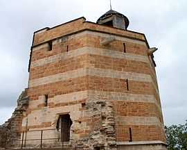
From the 13th century, the Trévoux river toll became important, and the town built a castle and walls.
On the 30th of June 1417, the local baron issued a decree allowing the local Jewish population to continue to study the Talmud, contrary to the decision taken in Chambéry in January 1417 as a result of which Jewish books had been seized and burned.
In 1523, the French king François the 1st confiscated the Dombes region and founded a parliament for the region in Lyon.
At the end of the 17th century, two important sovereign princes, Anne-Marie Louise of Orléans, Duchess of Montpensier known as "la Grande Mademoiselle", and her successor Louis-Auguste of Bourbon, duke of Maine, raised two monuments which are still notable in the landscape - the Montpensier hospital and the Palace of the Dombes Parliament.
In 1560, the Dombes region fell to the Bourbons. The town became rich as the capital of Dombes principality and seat of its parliament from 1697 to 1771. The town is also known at this time for a dictionnary, printed there from 1704 to 1771 by the Jesuits.
In 1762, the principalit of the Dombes was definitively absorbed into France.
The town was a sub-prefecture of Ain until 1926.
From the end of the 19th century until the 1950s, Trévoux was the global capital of the manufacture of synthetic diamonds.
Population
| Historical population | ||
|---|---|---|
| Year | Pop. | ±% |
| 1793 | 2,656 | — |
| 1800 | 2,530 | −4.7% |
| 1806 | 2,717 | +7.4% |
| 1821 | 3,016 | +11.0% |
| 1831 | 2,556 | −15.3% |
| 1836 | 2,559 | +0.1% |
| 1841 | 2,684 | +4.9% |
| 1846 | 2,532 | −5.7% |
| 1851 | 3,071 | +21.3% |
| 1856 | 2,749 | −10.5% |
| 1861 | 2,794 | +1.6% |
| 1866 | 2,863 | +2.5% |
| 1872 | 2,655 | −7.3% |
| 1876 | 2,889 | +8.8% |
| 1881 | 2,698 | −6.6% |
| 1886 | 2,661 | −1.4% |
| 1891 | 2,687 | +1.0% |
| 1896 | 2,662 | −0.9% |
| 1901 | 2,821 | +6.0% |
| 1906 | 2,624 | −7.0% |
| 1911 | 3,072 | +17.1% |
| 1921 | 2,941 | −4.3% |
| 1926 | 3,122 | +6.2% |
| 1931 | 3,093 | −0.9% |
| 1936 | 3,004 | −2.9% |
| 1946 | 2,961 | −1.4% |
| 1954 | 3,229 | +9.1% |
| 1962 | 3,594 | +11.3% |
| 1968 | 4,231 | +17.7% |
| 1975 | 4,583 | +8.3% |
| 1982 | 4,982 | +8.7% |
| 1990 | 6,092 | +22.3% |
| 1999 | 6,392 | +4.9% |
| 2008 | 6,768 | +5.9% |
Personalities
Trévoux was the birthplace of
- Arthur Giry (1848–1899), historian.
- François-Marie Treyve (1847–1906) writer and landscape gardener. He designed the park of the Célestins in Vichy and formed in 1881 the Établissements Treyve-Marie.
See also
References
External links
| Wikimedia Commons has media related to Trévoux. |
.svg.png)