Tosya
From Wikipedia, the free encyclopedia
| Tosya | |
|---|---|
| District | |
 | |
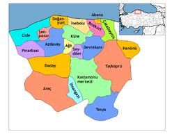 | |
 Tosya | |
| Coordinates: 41°06′N 34°02′E / 41.100°N 34.033°E | |
| Country |
|
| Region | Black Sea |
| Province | Kastamonu |
| Government | |
| • Mayor | Kazım Şahin (MHP) |
| Area[1] | |
| • District | 1,185.62 km2 (457.77 sq mi) |
| Elevation | 1,231 m (4,039 ft) |
| Population (2012)[2] | |
| • Urban | 28,097 |
| • District | 40,547 |
| • District Density | 34/km2 (89/sq mi) |
| Time zone | EET (UTC+2) |
| • Summer (DST) | EEST (UTC+3) |
| Postal code | 37300 |
| Area code(s) | 366 |
| Licence plate | 37 |
| Website | www.tosya.bel.tr |
Tosya (Ottoman Turkish: طوسيه) is a town and district of the Kastamonu Province in the Black Sea region of Turkey. According to the 2000 census, the population of the district is 41,995 of which 23,257 live in the town of Tosya.[3] The district covers an area of 1,186 km2 (458 sq mi),[4] and the town lies at an elevation of 1,231 m (4,039 ft). The district produces a third of Turkey's total rice harvest. Timber is another important industry in Tosya.
Notes
- ↑ "Area of regions (including lakes), km²". Regional Statistics Database. Turkish Statistical Institute. 2002. Retrieved 2013-03-05.
- ↑ "Population of province/district centers and towns/villages by districts - 2012". Address Based Population Registration System (ABPRS) Database. Turkish Statistical Institute. Retrieved 2013-02-27.
- ↑ Turkish Statistical Institute. "Census 2000, Key statistics for urban areas of Turkey" (XLS) (in Turkish). Retrieved 2008-11-03.
- ↑ Statoids. "Statistical information on districts of Turkey" (in English). Retrieved 2008-11-28.
References
- Falling Rain Genomics, Inc. "Geographical information on Tosya, Turkey" (in English). Retrieved 2008-11-03.
External links
![]() Media related to Kilkuyu, Tosya at Wikimedia Commons
Media related to Kilkuyu, Tosya at Wikimedia Commons
- Tosya Municipality (Turkish)
- District governorship official website (Turkish)
| ||||||||||||||||||||||||||||||||||||||||||||||||||||||
Coordinates: 41°05′50″N 34°02′13″E / 41.09722°N 34.03694°E
This article is issued from Wikipedia. The text is available under the Creative Commons Attribution/Share Alike; additional terms may apply for the media files.