Tosantos
| Tosantos | |||
|---|---|---|---|
| Municipality and town | |||
 | |||
| |||
 | |||
| Country | Spain | ||
| Autonomous community |
| ||
| Province |
| ||
| Comarca | Montes de Oca | ||
| Area | |||
| • Total | 5 km2 (2 sq mi) | ||
| Elevation | 818 m (2,684 ft) | ||
| Population (2004) | |||
| • Total | 60 | ||
| • Density | 12.0/km2 (31/sq mi) | ||
| Time zone | CET (UTC+1) | ||
| • Summer (DST) | CEST (UTC+2) | ||
| Postal code | 09258 | ||
| Website | http://www.tosantos.es/ | ||
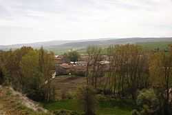
Tosantos is a municipality and town located in the province of Burgos, Castile and León, Spain. According to the 2004 census (INE), the municipality has a population of 60 inhabitants. Tosantos is located on the Camino de Santiago de Compostells, a 1200 year old pilgrimage route that runs through France and Northern Spain to the Spanish city of Santiago. The hamlet has a pilgrim hostel which is open from April through October and hosts up to 50 pilgrims a night.
800 years ago a woman, known as La Hermita, lived in a cave in the cliffs above Tosantos and ministered to the passing Pilgrims. A chapel has been built into that cave and once a year, on Fiesta day, the inhabitants of Tosantos hold a procession through the town, up the winding path to the cave and give thanks to God, Santa Maria and La Hermita for blessing the town.
Coordinates: 42°25′N 3°14′W / 42.417°N 3.233°W

